
A map in 5 weeks: How Cyril Radcliffe carved India & Pakistan changing millions of lives
Sir Cyril Radcliffe was not a politician, administrator or geographer with years of experience in the subcontinent. He was a barrister. Yet, by August 1947, his decisions would determine where millions of people would wake up as citizens of a different country.
- Aug 9, 2026,
- Updated Aug 9, 2026 8:57 PM IST
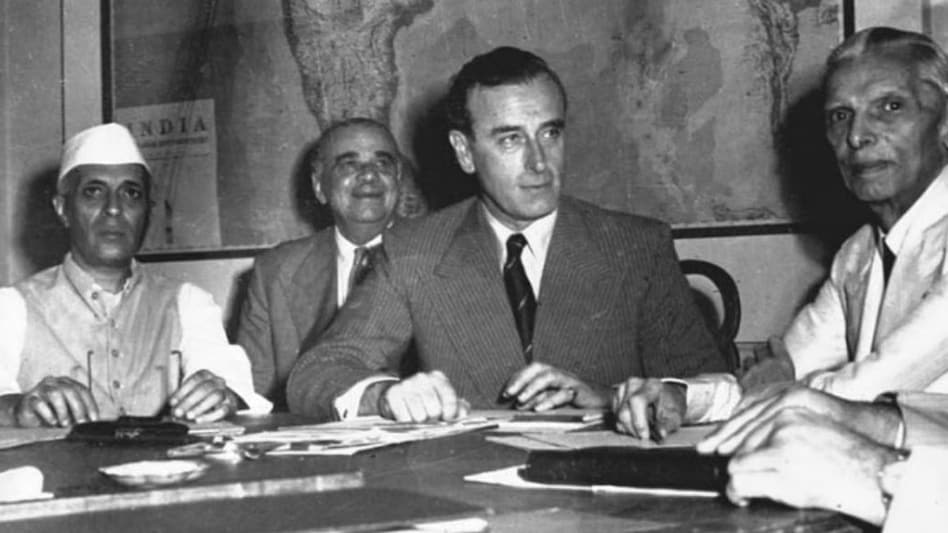
On July 8, 1947, a British lawyer who had never visited India arrived in a country racing towards independence. Sir Cyril Radcliffe had little more than five weeks to do what would become one of the most consequential cartographic exercises in modern history: draw the boundaries between India and Pakistan.
He was not a politician, administrator or geographer with years of experience in the subcontinent. He was a barrister. Yet, by August 1947, his decisions would determine where millions of people would wake up as citizens of a different country.
Radcliffe was appointed chairman of two Boundary Commissions — one for Punjab and another for Bengal. Each commission had four members, two nominated by the Indian National Congress and two by the Muslim League. With the representatives often divided along political lines, Radcliffe effectively became the final arbiter.
A map, a deadline and an impossible task
The assignment was staggering. The commissions had to divide Punjab and Bengal primarily by identifying contiguous Muslim and non-Muslim majority areas, while also considering other factors, including communications, natural boundaries, rivers and irrigation systems.
The problem was time. Radcliffe arrived in India on July 8 and had roughly five weeks to complete the task before the British transfer of power. The final award was submitted shortly before Independence but was not made public until August 17 — two days after India became independent and three days after Pakistan's independence.
The haste was extraordinary. The line was being drawn through areas where religious communities were deeply interwoven, while roads, railway lines, canals, villages, markets and family networks had developed without regard for a future international boundary.
There was no clean line available.
Punjab: Where the border cut through a complex society
Punjab presented perhaps the most difficult challenge. Muslims formed the majority overall, but Hindus and Sikhs were heavily concentrated in several areas. Communities were not neatly separated into two geographical blocks.
Any division based largely on population majorities risked leaving substantial minorities on the opposite side.
The eventual boundary split Punjab into West Punjab, which became part of Pakistan, and East Punjab, which went to India. It also disrupted an integrated network of irrigation, transport and communications. The partition of Punjab would become one of the main theatres of the violence and mass displacement that followed.
Bengal was divided too
Radcliffe's second major task was Bengal. The Bengal Presidency was similarly diverse, with Muslim-majority areas concentrated in the east and substantial Hindu populations in the west and elsewhere. The resulting boundary created East Bengal as part of Pakistan and West Bengal as part of India.
The Bengal demarcation stretched for thousands of kilometres, while the Punjab boundary covered hundreds of kilometres. The lines were anything but simple geographical divisions; they cut across an existing social and economic landscape. The consequences were immediate.
The line became a human catastrophe
When the new boundaries became known, millions discovered that the places they called home were now on the other side of an international border.
Historians estimate that roughly 12-15 million people were displaced or forced to migrate during Partition, while more than a million people are believed to have died, although estimates vary considerably.
Hindus and Sikhs moved towards India, while large numbers of Muslims moved towards Pakistan. Trains, roads and refugee columns became symbols of one of the largest and most traumatic population movements of the 20th century.
The violence was particularly devastating in Punjab, while Bengal and other regions also experienced displacement, communal violence and long-term disruption.
Why did Radcliffe accept the task?
The British government needed someone who could be presented as an impartial outsider. Radcliffe was a highly regarded barrister but had no previous experience of India.
That distance was seen as an advantage: he had no established political ties or local interests. But it also meant he was trying to understand an extraordinarily complicated region in weeks.
He had to work with demographic data and maps while confronting competing claims from political representatives. The commissions themselves were frequently deadlocked, leaving Radcliffe with enormous responsibility for the final decisions.
The border was announced after Independence
Perhaps one of the strangest details of Partition is that many people celebrated Independence without knowing precisely where the new border would run.
India became independent on August 15, 1947, while Pakistan became independent on August 14. The Radcliffe Award was publicly announced on August 17.
By then, the two new countries had already begun their lives. Radcliffe's line was no longer simply a line on paper. It was a new political reality.
Radcliffe's final departure
The British lawyer left India after completing the assignment and never returned. According to accounts of his time in India, Radcliffe was deeply disturbed by the violence and later destroyed his papers and declined his fee.
His name, however, remained attached to the boundary.
The Radcliffe Line became the dividing line between India and Pakistan in Punjab and, in the east, formed the basis of the India-East Pakistan boundary. After East Pakistan became Bangladesh in 1971, much of that eastern boundary became the India-Bangladesh border.
In five weeks, Cyril Radcliffe went from an outsider unfamiliar with India to the man whose name became synonymous with one of the most consequential borders in modern history. For the subcontinent, its consequences have lasted generations.
The map he helped draw reshaped homes, identities, economies and political geography. It separated families, divided communities and created a border whose legacy remains deeply embedded in India, Pakistan and Bangladesh.
On July 8, 1947, a British lawyer who had never visited India arrived in a country racing towards independence. Sir Cyril Radcliffe had little more than five weeks to do what would become one of the most consequential cartographic exercises in modern history: draw the boundaries between India and Pakistan.
He was not a politician, administrator or geographer with years of experience in the subcontinent. He was a barrister. Yet, by August 1947, his decisions would determine where millions of people would wake up as citizens of a different country.
Radcliffe was appointed chairman of two Boundary Commissions — one for Punjab and another for Bengal. Each commission had four members, two nominated by the Indian National Congress and two by the Muslim League. With the representatives often divided along political lines, Radcliffe effectively became the final arbiter.
A map, a deadline and an impossible task
The assignment was staggering. The commissions had to divide Punjab and Bengal primarily by identifying contiguous Muslim and non-Muslim majority areas, while also considering other factors, including communications, natural boundaries, rivers and irrigation systems.
The problem was time. Radcliffe arrived in India on July 8 and had roughly five weeks to complete the task before the British transfer of power. The final award was submitted shortly before Independence but was not made public until August 17 — two days after India became independent and three days after Pakistan's independence.
The haste was extraordinary. The line was being drawn through areas where religious communities were deeply interwoven, while roads, railway lines, canals, villages, markets and family networks had developed without regard for a future international boundary.
There was no clean line available.
Punjab: Where the border cut through a complex society
Punjab presented perhaps the most difficult challenge. Muslims formed the majority overall, but Hindus and Sikhs were heavily concentrated in several areas. Communities were not neatly separated into two geographical blocks.
Any division based largely on population majorities risked leaving substantial minorities on the opposite side.
The eventual boundary split Punjab into West Punjab, which became part of Pakistan, and East Punjab, which went to India. It also disrupted an integrated network of irrigation, transport and communications. The partition of Punjab would become one of the main theatres of the violence and mass displacement that followed.
Bengal was divided too
Radcliffe's second major task was Bengal. The Bengal Presidency was similarly diverse, with Muslim-majority areas concentrated in the east and substantial Hindu populations in the west and elsewhere. The resulting boundary created East Bengal as part of Pakistan and West Bengal as part of India.
The Bengal demarcation stretched for thousands of kilometres, while the Punjab boundary covered hundreds of kilometres. The lines were anything but simple geographical divisions; they cut across an existing social and economic landscape. The consequences were immediate.
The line became a human catastrophe
When the new boundaries became known, millions discovered that the places they called home were now on the other side of an international border.
Historians estimate that roughly 12-15 million people were displaced or forced to migrate during Partition, while more than a million people are believed to have died, although estimates vary considerably.
Hindus and Sikhs moved towards India, while large numbers of Muslims moved towards Pakistan. Trains, roads and refugee columns became symbols of one of the largest and most traumatic population movements of the 20th century.
The violence was particularly devastating in Punjab, while Bengal and other regions also experienced displacement, communal violence and long-term disruption.
Why did Radcliffe accept the task?
The British government needed someone who could be presented as an impartial outsider. Radcliffe was a highly regarded barrister but had no previous experience of India.
That distance was seen as an advantage: he had no established political ties or local interests. But it also meant he was trying to understand an extraordinarily complicated region in weeks.
He had to work with demographic data and maps while confronting competing claims from political representatives. The commissions themselves were frequently deadlocked, leaving Radcliffe with enormous responsibility for the final decisions.
The border was announced after Independence
Perhaps one of the strangest details of Partition is that many people celebrated Independence without knowing precisely where the new border would run.
India became independent on August 15, 1947, while Pakistan became independent on August 14. The Radcliffe Award was publicly announced on August 17.
By then, the two new countries had already begun their lives. Radcliffe's line was no longer simply a line on paper. It was a new political reality.
Radcliffe's final departure
The British lawyer left India after completing the assignment and never returned. According to accounts of his time in India, Radcliffe was deeply disturbed by the violence and later destroyed his papers and declined his fee.
His name, however, remained attached to the boundary.
The Radcliffe Line became the dividing line between India and Pakistan in Punjab and, in the east, formed the basis of the India-East Pakistan boundary. After East Pakistan became Bangladesh in 1971, much of that eastern boundary became the India-Bangladesh border.
In five weeks, Cyril Radcliffe went from an outsider unfamiliar with India to the man whose name became synonymous with one of the most consequential borders in modern history. For the subcontinent, its consequences have lasted generations.
The map he helped draw reshaped homes, identities, economies and political geography. It separated families, divided communities and created a border whose legacy remains deeply embedded in India, Pakistan and Bangladesh.