
Weather alert: Monsoon begins retreat; western disturbance brings rain to UP, Uttarakhand & Delhi
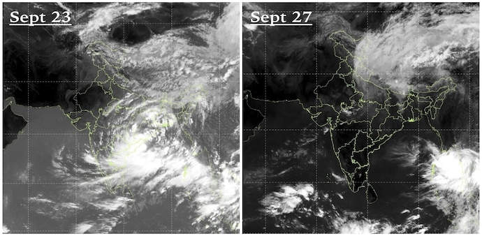
While the September 23 image shows widespread cloud cover over northern and northeastern India, the September 27 image shows much of northwestern and central India relatively clear.
- Sep 27, 2026,
- Updated Sep 27, 2026 12:50 PM IST
India’s southwest monsoon is entering its final phase, with satellite images showing a clear shift in cloud patterns as a Western Disturbance moves across northern India and the monsoon begins to retreat, India Today reported on Sunday.
Images captured by India’s INSAT-3DS satellite on September 23 and September 27 show the changing weather conditions across the country. While the September 23 image shows widespread cloud cover over northern and northeastern India, the September 27 image shows much of northwestern and central India relatively clear.
The change comes as the southwest monsoon continues its withdrawal from India, with the process already underway in parts of northwest India and gradually progressing towards central and eastern regions.
Don't Miss: El Niño's weather paradox: How one climate event causes floods and droughts
Western Disturbance changes cloud patterns
The Western Disturbance swept across northern India on Friday and Saturday, changing the distribution of clouds over the region as rain-bearing clouds linked to the southwest monsoon began to disappear.
A Western Disturbance is an eastward-moving weather system that originates in the Mediterranean region. It can bring cloudiness, rain and thunderstorms to parts of northern India, particularly when it interacts with moisture from other weather systems.
The interaction of the Western Disturbance with a depression over central India has helped trigger rain across parts of Uttar Pradesh, Uttarakhand and Delhi-NCR, even as the monsoon withdrawal continues.
Must Read: 'Biggest El Niño ever recorded': Economist Sanjeev Sanyal highlights record-breaking Pacific heat
When will the monsoon disappear?
Rainfall activity is expected to ease across several parts of the country towards the end of September, with September 29 emerging as a potential turning point for the transition to drier weather.
However, the complete withdrawal of the southwest monsoon from India does not happen on a fixed date.
The India Meteorological Department considers rainfall cessation, declining atmospheric moisture and changes in wind circulation before declaring further withdrawal.
Even after the monsoon withdraws, local weather systems can continue to trigger rainfall, particularly over southern and eastern India.
The two satellite images capture the seasonal transition as India moves from its four-month southwest monsoon season towards the cooler months ahead.
India’s southwest monsoon is entering its final phase, with satellite images showing a clear shift in cloud patterns as a Western Disturbance moves across northern India and the monsoon begins to retreat, India Today reported on Sunday.
Images captured by India’s INSAT-3DS satellite on September 23 and September 27 show the changing weather conditions across the country. While the September 23 image shows widespread cloud cover over northern and northeastern India, the September 27 image shows much of northwestern and central India relatively clear.
The change comes as the southwest monsoon continues its withdrawal from India, with the process already underway in parts of northwest India and gradually progressing towards central and eastern regions.
Don't Miss: El Niño's weather paradox: How one climate event causes floods and droughts
Western Disturbance changes cloud patterns
The Western Disturbance swept across northern India on Friday and Saturday, changing the distribution of clouds over the region as rain-bearing clouds linked to the southwest monsoon began to disappear.
A Western Disturbance is an eastward-moving weather system that originates in the Mediterranean region. It can bring cloudiness, rain and thunderstorms to parts of northern India, particularly when it interacts with moisture from other weather systems.
The interaction of the Western Disturbance with a depression over central India has helped trigger rain across parts of Uttar Pradesh, Uttarakhand and Delhi-NCR, even as the monsoon withdrawal continues.
Must Read: 'Biggest El Niño ever recorded': Economist Sanjeev Sanyal highlights record-breaking Pacific heat
When will the monsoon disappear?
Rainfall activity is expected to ease across several parts of the country towards the end of September, with September 29 emerging as a potential turning point for the transition to drier weather.
However, the complete withdrawal of the southwest monsoon from India does not happen on a fixed date.
The India Meteorological Department considers rainfall cessation, declining atmospheric moisture and changes in wind circulation before declaring further withdrawal.
Even after the monsoon withdraws, local weather systems can continue to trigger rainfall, particularly over southern and eastern India.
The two satellite images capture the seasonal transition as India moves from its four-month southwest monsoon season towards the cooler months ahead.