
China’s Brahmaputra mega-dam sparks seismic fears: Why should India be worried
Some researchers have argued that the enormous weight of water stored behind the dam may have altered stresses on an underlying fault, potentially contributing to what scientists call reservoir-triggered seismicity (RTS).
- Aug 20, 2026,
- Updated Aug 20, 2026 2:08 PM IST
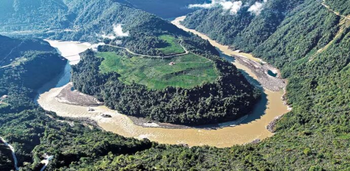
Geostrategist and security analyst Brahma Chellaney has raised fresh concerns over China’s construction of a massive hydropower project on the Yarlung Tsangpo, the river that enters India as the Brahmaputra, warning that geological instability at the site could pose risks to millions of people downstream.
In a post on X (formerly Twitter), Chellaney questioned what he described as New Delhi’s silence over the project and urged India to demand greater transparency from Beijing, including access for independent experts to assess the dam site.
Chinese scientists warn of geological risks
Chellaney cited a recent paper published in Sedimentary Geology and Tethyan Geology, a journal overseen by the state-run China Geological Survey. According to the analysis cited by him, Chinese geologists have warned that the project is located along a geological fault and that the construction area has a “loose structure and weak cohesion.”
The researchers reportedly cautioned that fault activity or an earthquake could trigger instability along reservoir slopes, potentially threatening the integrity of the dam and nearby infrastructure.
The paper has also recommended measures including reinforcing reservoir slopes and installing retaining structures, according to Chellaney.
The concerns are particularly significant because the project is expected to impound an enormous volume of water from the Yarlung Tsangpo. The river flows through Tibet before entering India through Arunachal Pradesh and continuing across Assam and into Bangladesh.
A project far larger than Three Gorges
The proposed dam has been described as a project on a scale unprecedented in hydropower development. Chellaney says it could be almost three times the size of China’s Three Gorges Dam, currently the world’s largest hydropower project.
Its location adds another layer of concern.
The dam is being constructed in the Himalayan region, one of the world's most seismically active zones, where the Indian and Eurasian tectonic plates are colliding. The region has experienced some of Asia’s most powerful earthquakes.
For India, the geographical reality is critical: any major accident, landslide, structural failure or sudden release of reservoir water could have consequences downstream, particularly across the Brahmaputra basin.
Why reservoir-triggered earthquakes are a concern
Chellaney also pointed to the controversy surrounding the 2008 earthquake in China's Sichuan region. The devastating earthquake killed nearly 90,000 people and prompted scientific debate over whether the nearby Zipingpu Dam had played a role.
Some researchers have argued that the enormous weight of water stored behind the dam may have altered stresses on an underlying fault, potentially contributing to what scientists call reservoir-triggered seismicity (RTS).
The issue remains scientifically complex, and establishing a direct causal link between reservoirs and major earthquakes is difficult. However, the possibility is one reason large dams in earthquake-prone areas receive intense geological scrutiny. That history has added significance for the Brahmaputra project because of its location in an active tectonic belt.
Why India is watching closely
The Brahmaputra is one of the most important rivers in northeastern India. Millions of people depend on its waters and the surrounding floodplains for agriculture, livelihoods and transportation.
Any major disruption to the river system could therefore have consequences extending well beyond the immediate dam site.
The risk is not limited to India. Bangladesh lies farther downstream in the Brahmaputra basin, meaning a major incident could potentially affect communities across international borders.
At the same time, the project raises broader concerns over China's control of an upstream river whose waters are vital to several downstream countries.
The information gap
One of Chellaney’s central criticisms is the lack of transparency surrounding the project.
He argues that India should seek detailed information from Beijing about the dam’s design, geological assessments, reservoir management and emergency-response mechanisms.
He has also called for Indian and international experts to be allowed to visit the construction site and conduct an independent scientific assessment.
For New Delhi, the challenge is particularly sensitive because the Brahmaputra is both an economic lifeline and a strategic water resource. China's position upstream gives it significant influence over the river’s flow before it enters India.
Is the ‘water bomb’ warning justified?
Calling the project a potential “water bomb” highlights the worst-case scenario rather than establishing that a disaster is inevitable.
Large dams are engineered to withstand geological and hydrological stresses, and the existence of an active fault does not automatically mean that a dam will fail. Likewise, scientific warnings about reservoir-triggered seismicity require careful assessment rather than assumptions about causation.
But the scale of the project, its location in a highly active seismic zone and its potential impact on downstream populations make independent scientific scrutiny particularly important. For India, the debate is therefore not simply about China building another hydropower project. It is about the safety and security of a river system shared by multiple countries.
Geostrategist and security analyst Brahma Chellaney has raised fresh concerns over China’s construction of a massive hydropower project on the Yarlung Tsangpo, the river that enters India as the Brahmaputra, warning that geological instability at the site could pose risks to millions of people downstream.
In a post on X (formerly Twitter), Chellaney questioned what he described as New Delhi’s silence over the project and urged India to demand greater transparency from Beijing, including access for independent experts to assess the dam site.
Chinese scientists warn of geological risks
Chellaney cited a recent paper published in Sedimentary Geology and Tethyan Geology, a journal overseen by the state-run China Geological Survey. According to the analysis cited by him, Chinese geologists have warned that the project is located along a geological fault and that the construction area has a “loose structure and weak cohesion.”
The researchers reportedly cautioned that fault activity or an earthquake could trigger instability along reservoir slopes, potentially threatening the integrity of the dam and nearby infrastructure.
The paper has also recommended measures including reinforcing reservoir slopes and installing retaining structures, according to Chellaney.
The concerns are particularly significant because the project is expected to impound an enormous volume of water from the Yarlung Tsangpo. The river flows through Tibet before entering India through Arunachal Pradesh and continuing across Assam and into Bangladesh.
A project far larger than Three Gorges
The proposed dam has been described as a project on a scale unprecedented in hydropower development. Chellaney says it could be almost three times the size of China’s Three Gorges Dam, currently the world’s largest hydropower project.
Its location adds another layer of concern.
The dam is being constructed in the Himalayan region, one of the world's most seismically active zones, where the Indian and Eurasian tectonic plates are colliding. The region has experienced some of Asia’s most powerful earthquakes.
For India, the geographical reality is critical: any major accident, landslide, structural failure or sudden release of reservoir water could have consequences downstream, particularly across the Brahmaputra basin.
Why reservoir-triggered earthquakes are a concern
Chellaney also pointed to the controversy surrounding the 2008 earthquake in China's Sichuan region. The devastating earthquake killed nearly 90,000 people and prompted scientific debate over whether the nearby Zipingpu Dam had played a role.
Some researchers have argued that the enormous weight of water stored behind the dam may have altered stresses on an underlying fault, potentially contributing to what scientists call reservoir-triggered seismicity (RTS).
The issue remains scientifically complex, and establishing a direct causal link between reservoirs and major earthquakes is difficult. However, the possibility is one reason large dams in earthquake-prone areas receive intense geological scrutiny. That history has added significance for the Brahmaputra project because of its location in an active tectonic belt.
Why India is watching closely
The Brahmaputra is one of the most important rivers in northeastern India. Millions of people depend on its waters and the surrounding floodplains for agriculture, livelihoods and transportation.
Any major disruption to the river system could therefore have consequences extending well beyond the immediate dam site.
The risk is not limited to India. Bangladesh lies farther downstream in the Brahmaputra basin, meaning a major incident could potentially affect communities across international borders.
At the same time, the project raises broader concerns over China's control of an upstream river whose waters are vital to several downstream countries.
The information gap
One of Chellaney’s central criticisms is the lack of transparency surrounding the project.
He argues that India should seek detailed information from Beijing about the dam’s design, geological assessments, reservoir management and emergency-response mechanisms.
He has also called for Indian and international experts to be allowed to visit the construction site and conduct an independent scientific assessment.
For New Delhi, the challenge is particularly sensitive because the Brahmaputra is both an economic lifeline and a strategic water resource. China's position upstream gives it significant influence over the river’s flow before it enters India.
Is the ‘water bomb’ warning justified?
Calling the project a potential “water bomb” highlights the worst-case scenario rather than establishing that a disaster is inevitable.
Large dams are engineered to withstand geological and hydrological stresses, and the existence of an active fault does not automatically mean that a dam will fail. Likewise, scientific warnings about reservoir-triggered seismicity require careful assessment rather than assumptions about causation.
But the scale of the project, its location in a highly active seismic zone and its potential impact on downstream populations make independent scientific scrutiny particularly important. For India, the debate is therefore not simply about China building another hydropower project. It is about the safety and security of a river system shared by multiple countries.