
Cyclone alert: Bay of Bengal storm keeps Chennai and Andhra coast on edge. Where will it strike?
The IMD has forecast heavy rainfall over the Andaman and Nicobar Islands on November 16. Wind speeds up to 60 kmph are expected over the Andaman Sea, the Andaman and Nicobar Islands, and large parts of the Bay of Bengal, strengthening to 80 kmph over the central Bay of Bengal from November 17.
- Nov 15, 2026,
- Updated Nov 15, 2026 2:49 PM IST
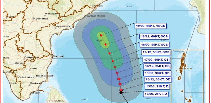
A depression over the southeast and adjoining southwest Bay of Bengal is projected to intensify into a cyclonic storm by Monday evening and escalate into a severe cyclonic storm on Tuesday. While the India Meteorological Department (IMD) has flagged a likely track toward the Andhra Pradesh coast, diverging weather models have kept both Andhra Pradesh and north Tamil Nadu on alert over its eventual landfall.
At 8:30 am IST on November 15, the system lay centered near Latitude 9.3°N and Longitude 86.9°E after moving nearly northwards at 10 kmph — roughly 630 km east of Trincomalee, 690 km west-southwest of Sri Vijaya Puram, 840 km east-southeast of Chennai, 1,010 km south-southeast of Visakhapatnam, and 1,130 km south-southeast of Gopalpur.
"It is very likely to move north-northwestwards, intensify further into a Cyclonic Storm over the central parts of south & adjoining westcentral Bay of Bengal on 16th November and into a Severe Cyclonic Storm over westcentral Bay of Bengal on 17th November, 2026. Thereafter, it is likely to intensify further and move northwestwards towards Andhra Pradesh coast during subsequent 2 days," the IMD posted on X (formally twitter).
The IMD has forecast heavy rainfall over the Andaman and Nicobar Islands on November 16. Wind speeds up to 60 kmph are expected over the Andaman Sea, the Andaman and Nicobar Islands, and large parts of the Bay of Bengal, strengthening to 80 kmph over the central Bay of Bengal from November 17.
Fishermen at sea have been advised to return to the coast immediately and avoid venturing into the Andaman Sea and affected Bay areas on Monday.
Despite the IMD's projected track toward Andhra Pradesh, the exact landfall remains uncertain. Weather blogger Pradeep John noted that while operational models suggest a movement toward Andhra Pradesh, several artificial intelligence-based models favour north Tamil Nadu.
The system's proximity and path will determine rainfall across Tamil Nadu, particularly Chennai. Even if it crosses Andhra Pradesh, a landfall near Nellore could bring substantial rain to Chennai and neighbouring districts, whereas a landfall farther north toward Ongole or Machilipatnam would leave north Tamil Nadu with less rain, Pradeep said.
Meteorologists have warned against treating early projections as final, citing past storms that shifted course late. Cyclone Thane in December 2011 was initially forecast to hit near Chennai before shifting south in the final 36 hours to strike near Cuddalore on December 30.
Cyclones Vardah (2016), Nivar (2020), and Fengal (2024) similarly saw track changes as observations improved. Forecasters urged residents to rely on official updates rather than speculative projections that cause unnecessary anxiety.
Separately, a western disturbance is likely to bring light to moderate rain or snow over the Western Himalayan Region and light rain over the plains of Northwest India on Sunday. The IMD also forecast thunderstorms with lightning and gusty winds over Rajasthan and Uttarakhand, alongside dense fog in isolated parts of West Uttar Pradesh.
A depression over the southeast and adjoining southwest Bay of Bengal is projected to intensify into a cyclonic storm by Monday evening and escalate into a severe cyclonic storm on Tuesday. While the India Meteorological Department (IMD) has flagged a likely track toward the Andhra Pradesh coast, diverging weather models have kept both Andhra Pradesh and north Tamil Nadu on alert over its eventual landfall.
At 8:30 am IST on November 15, the system lay centered near Latitude 9.3°N and Longitude 86.9°E after moving nearly northwards at 10 kmph — roughly 630 km east of Trincomalee, 690 km west-southwest of Sri Vijaya Puram, 840 km east-southeast of Chennai, 1,010 km south-southeast of Visakhapatnam, and 1,130 km south-southeast of Gopalpur.
"It is very likely to move north-northwestwards, intensify further into a Cyclonic Storm over the central parts of south & adjoining westcentral Bay of Bengal on 16th November and into a Severe Cyclonic Storm over westcentral Bay of Bengal on 17th November, 2026. Thereafter, it is likely to intensify further and move northwestwards towards Andhra Pradesh coast during subsequent 2 days," the IMD posted on X (formally twitter).
The IMD has forecast heavy rainfall over the Andaman and Nicobar Islands on November 16. Wind speeds up to 60 kmph are expected over the Andaman Sea, the Andaman and Nicobar Islands, and large parts of the Bay of Bengal, strengthening to 80 kmph over the central Bay of Bengal from November 17.
Fishermen at sea have been advised to return to the coast immediately and avoid venturing into the Andaman Sea and affected Bay areas on Monday.
Despite the IMD's projected track toward Andhra Pradesh, the exact landfall remains uncertain. Weather blogger Pradeep John noted that while operational models suggest a movement toward Andhra Pradesh, several artificial intelligence-based models favour north Tamil Nadu.
The system's proximity and path will determine rainfall across Tamil Nadu, particularly Chennai. Even if it crosses Andhra Pradesh, a landfall near Nellore could bring substantial rain to Chennai and neighbouring districts, whereas a landfall farther north toward Ongole or Machilipatnam would leave north Tamil Nadu with less rain, Pradeep said.
Meteorologists have warned against treating early projections as final, citing past storms that shifted course late. Cyclone Thane in December 2011 was initially forecast to hit near Chennai before shifting south in the final 36 hours to strike near Cuddalore on December 30.
Cyclones Vardah (2016), Nivar (2020), and Fengal (2024) similarly saw track changes as observations improved. Forecasters urged residents to rely on official updates rather than speculative projections that cause unnecessary anxiety.
Separately, a western disturbance is likely to bring light to moderate rain or snow over the Western Himalayan Region and light rain over the plains of Northwest India on Sunday. The IMD also forecast thunderstorms with lightning and gusty winds over Rajasthan and Uttarakhand, alongside dense fog in isolated parts of West Uttar Pradesh.