
Monsoon update: Satellite imagery tracks final lap over North India before south shift
A fresh wave of heavy downpours is set to sweep across northern, eastern, and central parts of the country, as the IMD issued severe weather alerts extending through September 8.
- Sep 7, 2026,
- Updated Sep 7, 2026 2:57 PM IST
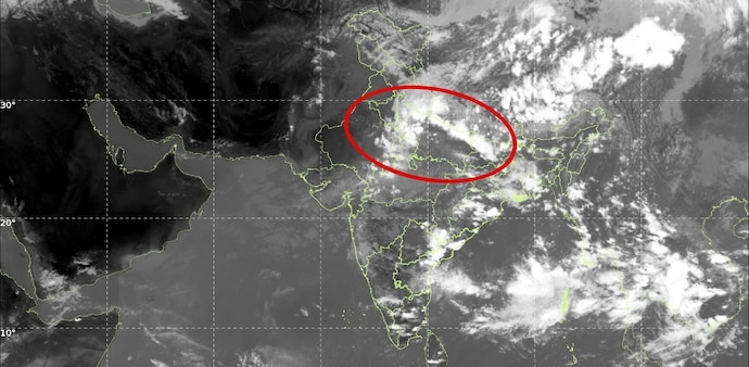
Massive cloud formations stretching across the northern, central, and eastern corridors of the country signaled a powerful late-season surge of the southwest monsoon, as captured by high-resolution imagery from India's INSAT-3DS satellite.
Dense atmospheric bands hung over the Himalayan region, the Indo-Gangetic plains, and central India, while aggressive convective activity and scattered thunderstorms continued to sweep eastern and northeastern regions.
The orbital observations confirm that despite entering the typical transitional period, the monsoon's atmospheric engine remains exceptionally active.
Weather forecast indicate that this sustained surge will persist for at least another week, maintaining elevated atmospheric moisture and bringing continued spells of heavy rainfall and thunderstorms across northern, central, and eastern India until around mid-September. Deep cloud coverage over the Bay of Bengal continues to pump a steady stream of moisture into eastern states.
However, a fundamental structural reorganization of the monsoon system is expected during the second half of the month. Model forecasts show the rain-bearing circulation gradually shifting down toward South India. By around September 20, North and Northwest India are projected to experience a sharp reduction in precipitation, paving the way for significantly drier conditions and marking the seasonal transition.
While the regional shift remains contingent on the positioning of the monsoon trough and developing atmospheric dynamics, current satellite observations make one thing clear: the monsoon is mounting a firm final stand over North India before packing up for the south.
Rainfall forecast
A fresh wave of heavy downpours is set to sweep across northern, eastern, and central parts of the country, as the India Meteorological Department (IMD) issued severe weather alerts extending through September 8. Widespread rainfall is expected to hit Bihar, Madhya Pradesh, Eastern Uttar Pradesh, Uttarakhand, West Bengal, and isolated pockets across North East India.
Along with intense rain, active convective systems are triggering persistent atmospheric instability across neighboring regions. The Met Department warned that active thunderstorm activity and lightning strikes will continue over Andhra Pradesh, Jharkhand, Odisha, Chhattisgarh, and Tamil Nadu through tomorrow.
Similar violent weather dynamics will linger across Puducherry, Karaikal, Vidarbha, Chhattisgarh, Gangetic West Bengal, and the Andaman and Nicobar Islands over the next two days.
In contrast to the wet spell up north and east, coastal belts in the south face muggy conditions. The IMD said that hot and humid weather will persist across Coastal Andhra Pradesh, Kerala, and Mahe through tomorrow.
Massive cloud formations stretching across the northern, central, and eastern corridors of the country signaled a powerful late-season surge of the southwest monsoon, as captured by high-resolution imagery from India's INSAT-3DS satellite.
Dense atmospheric bands hung over the Himalayan region, the Indo-Gangetic plains, and central India, while aggressive convective activity and scattered thunderstorms continued to sweep eastern and northeastern regions.
The orbital observations confirm that despite entering the typical transitional period, the monsoon's atmospheric engine remains exceptionally active.
Weather forecast indicate that this sustained surge will persist for at least another week, maintaining elevated atmospheric moisture and bringing continued spells of heavy rainfall and thunderstorms across northern, central, and eastern India until around mid-September. Deep cloud coverage over the Bay of Bengal continues to pump a steady stream of moisture into eastern states.
However, a fundamental structural reorganization of the monsoon system is expected during the second half of the month. Model forecasts show the rain-bearing circulation gradually shifting down toward South India. By around September 20, North and Northwest India are projected to experience a sharp reduction in precipitation, paving the way for significantly drier conditions and marking the seasonal transition.
While the regional shift remains contingent on the positioning of the monsoon trough and developing atmospheric dynamics, current satellite observations make one thing clear: the monsoon is mounting a firm final stand over North India before packing up for the south.
Rainfall forecast
A fresh wave of heavy downpours is set to sweep across northern, eastern, and central parts of the country, as the India Meteorological Department (IMD) issued severe weather alerts extending through September 8. Widespread rainfall is expected to hit Bihar, Madhya Pradesh, Eastern Uttar Pradesh, Uttarakhand, West Bengal, and isolated pockets across North East India.
Along with intense rain, active convective systems are triggering persistent atmospheric instability across neighboring regions. The Met Department warned that active thunderstorm activity and lightning strikes will continue over Andhra Pradesh, Jharkhand, Odisha, Chhattisgarh, and Tamil Nadu through tomorrow.
Similar violent weather dynamics will linger across Puducherry, Karaikal, Vidarbha, Chhattisgarh, Gangetic West Bengal, and the Andaman and Nicobar Islands over the next two days.
In contrast to the wet spell up north and east, coastal belts in the south face muggy conditions. The IMD said that hot and humid weather will persist across Coastal Andhra Pradesh, Kerala, and Mahe through tomorrow.