
Will rain play spoilsport for Opposition's SC march? Delhi wakes up to chilly morning amid late night downpour
The India Meteorological Department (IMD) had earlier warned of severe weather conditions across Delhi, Haryana, and Punjab, forecasting high-speed winds reaching up to 60 kilometers per hour alongside potential hailstorms.
- Oct 12, 2026,
- Updated Oct 12, 2026 6:56 AM IST
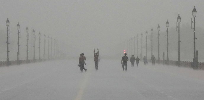
Heavy rainfall throughout the night threatens to derail Opposition's planned march to Supreme Court today, as dark skies opened up across the National Capital Region on October 11 post midnight, unleashing heavy downpours accompanied by intense thunderstorms and gale-force winds that swept through the midnight hours. The downpour continued till early morning hours of October 12.
The sudden weather shift triggered a sharp drop in temperatures, bringing a brisk chill to the region following a day of stifling humidity.
The India Meteorological Department (IMD) had earlier warned of severe weather conditions across Delhi, Haryana, and Punjab, forecasting high-speed winds reaching up to 60 kilometers per hour alongside potential hailstorms.
The overnight tempest also disrupted Navratri celebrations leaving festival organisers scrambling to secure venues. Visuals from areas like Jantar Mantar and Kalkaji showed waterlogged streets and deserted protest sites as the downpour battered the city.
Red warning across capital
The IMD has issued a high-priority red Warning valid from 06:00 am to 09:00 am for today. Severe thunderstorms and lightning accompanied by gale-force gusty winds around 60 kmph and heavy downpours exceeding 15 mm per hour are heavily pounding all districts across the capital, including:
- Central Delhi, East Delhi, and New Delhi
- North Delhi, North East Delhi, and North West Delhi
- Shahdara, South Delhi, and South East Delhi
- South West Delhi and West Delhi
Orange alert for NCR
Surrounding satellite cities face an Orange Alert (Be Prepared) during the same three-hour window, with moderate-to-intense rainfall ranging between 5 to 15 mm/hour and gusty winds reaching 40 to 60 kmph:
- Haryana: Faridabad, Gurgaon, Rohtak, and Sonipat
- Uttar Pradesh: Amroha, Baghpat, Bijnor, Bulandshahr, Gautam Budh Nagar, Ghaziabad, Hapur, Meerut, and Sambhal
With waterlogged streets and continuous downpours disrupting early morning routines, authorities urge commuters and residents to stay alert. Citizens are strongly advised to avoid sheltering under trees or weak structures, steer clear of waterlogged and flood-prone corridors, check real-time traffic updates, and strictly follow official advisories.
Regional warnings & multi-day forecasts
According to the weekly weather bulletin issued by the IMD, severe weather warnings and rainfall activity extend across multiple administrative subdivisions and dates.
Northwest Region: Isolated heavy rainfall, thunderstorms, lightning, and hailstorms were forecasted for Haryana, Chandigarh & Delhi, Punjab, Himachal Pradesh, Jammu-Kashmir-Ladakh-Gilgit-Baltistan-Muzaffarabad, and Uttarakhand on October 11.
Extended Outlook: Scattered-to-fairly widespread rainfall is projected to continue across Northwest India, with specific weather systems affecting Punjab, Haryana, Chandigarh & Delhi, and Uttar Pradesh spanning from October 11 through October 16.
Southern and Eastern Systems: Isolated heavy rainfall is expected over Kerala & Mahe and Tamil Nadu, Puducherry & Karaikal during October 16-17. Additionally, a low-pressure area is likely to form over the Southeast Bay of Bengal around October 13 under the influence of an upper-air cyclonic circulation.
The southwest monsoon withdrawal line continues to pass through Supaul, Ranchi, Sundargarh, Bargarh, Bijapur, Hyderabad, Belagavi and Panjim as of October 11 with conditions becoming favorable for further withdrawal from parts of eastern India, the Northern Peninsula, and northeast India over the subsequent two days.
Heavy rainfall throughout the night threatens to derail Opposition's planned march to Supreme Court today, as dark skies opened up across the National Capital Region on October 11 post midnight, unleashing heavy downpours accompanied by intense thunderstorms and gale-force winds that swept through the midnight hours. The downpour continued till early morning hours of October 12.
The sudden weather shift triggered a sharp drop in temperatures, bringing a brisk chill to the region following a day of stifling humidity.
The India Meteorological Department (IMD) had earlier warned of severe weather conditions across Delhi, Haryana, and Punjab, forecasting high-speed winds reaching up to 60 kilometers per hour alongside potential hailstorms.
The overnight tempest also disrupted Navratri celebrations leaving festival organisers scrambling to secure venues. Visuals from areas like Jantar Mantar and Kalkaji showed waterlogged streets and deserted protest sites as the downpour battered the city.
Red warning across capital
The IMD has issued a high-priority red Warning valid from 06:00 am to 09:00 am for today. Severe thunderstorms and lightning accompanied by gale-force gusty winds around 60 kmph and heavy downpours exceeding 15 mm per hour are heavily pounding all districts across the capital, including:
- Central Delhi, East Delhi, and New Delhi
- North Delhi, North East Delhi, and North West Delhi
- Shahdara, South Delhi, and South East Delhi
- South West Delhi and West Delhi
Orange alert for NCR
Surrounding satellite cities face an Orange Alert (Be Prepared) during the same three-hour window, with moderate-to-intense rainfall ranging between 5 to 15 mm/hour and gusty winds reaching 40 to 60 kmph:
- Haryana: Faridabad, Gurgaon, Rohtak, and Sonipat
- Uttar Pradesh: Amroha, Baghpat, Bijnor, Bulandshahr, Gautam Budh Nagar, Ghaziabad, Hapur, Meerut, and Sambhal
With waterlogged streets and continuous downpours disrupting early morning routines, authorities urge commuters and residents to stay alert. Citizens are strongly advised to avoid sheltering under trees or weak structures, steer clear of waterlogged and flood-prone corridors, check real-time traffic updates, and strictly follow official advisories.
Regional warnings & multi-day forecasts
According to the weekly weather bulletin issued by the IMD, severe weather warnings and rainfall activity extend across multiple administrative subdivisions and dates.
Northwest Region: Isolated heavy rainfall, thunderstorms, lightning, and hailstorms were forecasted for Haryana, Chandigarh & Delhi, Punjab, Himachal Pradesh, Jammu-Kashmir-Ladakh-Gilgit-Baltistan-Muzaffarabad, and Uttarakhand on October 11.
Extended Outlook: Scattered-to-fairly widespread rainfall is projected to continue across Northwest India, with specific weather systems affecting Punjab, Haryana, Chandigarh & Delhi, and Uttar Pradesh spanning from October 11 through October 16.
Southern and Eastern Systems: Isolated heavy rainfall is expected over Kerala & Mahe and Tamil Nadu, Puducherry & Karaikal during October 16-17. Additionally, a low-pressure area is likely to form over the Southeast Bay of Bengal around October 13 under the influence of an upper-air cyclonic circulation.
The southwest monsoon withdrawal line continues to pass through Supaul, Ranchi, Sundargarh, Bargarh, Bijapur, Hyderabad, Belagavi and Panjim as of October 11 with conditions becoming favorable for further withdrawal from parts of eastern India, the Northern Peninsula, and northeast India over the subsequent two days.