
UN adopts Equal Earth map: All about Africa’s true size, Mercator distortions and what changes now
UN has backed a new world map designed to show the relative size of continents more accurately, particularly correcting the way Africa is visually diminished on the traditional Mercator projection. The move could influence maps used in education, technology and governance, although the non-binding resolution does not require countries to abandon Mercator.
- Sep 5, 2026,
- Updated Sep 5, 2026 5:10 PM IST
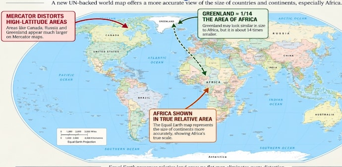
The United Nations has voted to move away from the centuries-old Mercator projection and promote the 2018 Equal Earth map, a design that more accurately represents the relative size of the world's continents. The resolution, backed by 164 countries including India, seeks to address long-standing distortions in how Africa and other regions are depicted on conventional world maps. The US was the only country to vote against the resolution, while six countries abstained.
So, what exactly is changing?
The biggest difference is the apparent size of continents. According to a report in the Guardian, the Mercator projection, created by Flemish cartographer Gerardus Mercator in 1569, was designed primarily to help sailors navigate the seas. It represents the spherical Earth on a flat surface and preserves directions, allowing sailors to plot straight-line courses.
However, this comes at the cost of distorting the size of landmasses. Regions closer to the poles are visually enlarged, while areas around the Equator appear smaller than they actually are. Countries and regions such as Canada, Russia, the United States and Europe therefore appear disproportionately large, while Africa appears much smaller.
As per the report, One of the most striking examples is Greenland and Africa. On a Mercator map, Greenland can appear comparable in size to Africa. In reality, Africa is about 14 times larger than Greenland.
MUST READ: Zero rabies deaths since 2023: WHO validates Bhutan for historic health milestone
The Equal Earth projection, developed in 2018 by an international team of cartographers, is designed to correct this problem. It is an equal-area projection, meaning it represents the relative sizes of continents much more accurately. Africa consequently appears substantially larger relative to Europe, North America and Greenland than it does on a Mercator map.
But Equal Earth is not a distortion-free map. Because Earth is a three-dimensional sphere, representing it on a flat surface inevitably involves trade-offs. A map can distort area, shape, distance or direction. Equal Earth prioritises accurate land areas, but shapes and distances can still become distorted, particularly towards the poles.
Why is the change significant?
The debate is not merely about cartography. Critics of Mercator argue that its visual enlargement of northern regions and shrinking of equatorial regions has reinforced Western-centric perceptions of the world. Some activists describe this as “cartographic colonialism”, arguing that the depiction can influence perceptions of Africa's importance in education, geopolitics and development.
The push for change has been led in part by Togo on behalf of the African Union. The AU endorsed the #CorrectTheMap campaign, which promoted the Equal Earth design. Supporters say changing the projection could help reverse perceptions of Africa and “decolonise” global curricula.
DO READ: China’s oil use drops sharply: Expert says EV shift is changing global energy demand
Will every map now change?
Not immediately. The UN resolution is not legally binding, meaning countries, schools, companies and technology platforms are not required to stop using Mercator. However, the vote could encourage changes in school textbooks, classroom maps, technology and official cartography.
Some institutions have already moved away from Mercator. Google Maps switched its desktop version to a 3D globe in 2018, although Mercator remains available and is still the default on its mobile app. The World Bank uses Winkel Tripel or Equal Earth for static maps, while France has said it will move away from Mercator and use the Eckert IV projection.
Togo is also planning discussions with UNESCO, the African Union and technology companies, including Google Maps, on implementing the resolution.
The UN decision therefore represents less a ban on Mercator than a push towards a map that gives a more accurate visual picture of the world's land areas, while acknowledging that no flat map can perfectly reproduce a spherical Earth.
(With agency inputs)
DON'T MISS: Earth nearing climate red line: World set to cross 1.5°C warming threshold, warns UN body
The United Nations has voted to move away from the centuries-old Mercator projection and promote the 2018 Equal Earth map, a design that more accurately represents the relative size of the world's continents. The resolution, backed by 164 countries including India, seeks to address long-standing distortions in how Africa and other regions are depicted on conventional world maps. The US was the only country to vote against the resolution, while six countries abstained.
So, what exactly is changing?
The biggest difference is the apparent size of continents. According to a report in the Guardian, the Mercator projection, created by Flemish cartographer Gerardus Mercator in 1569, was designed primarily to help sailors navigate the seas. It represents the spherical Earth on a flat surface and preserves directions, allowing sailors to plot straight-line courses.
However, this comes at the cost of distorting the size of landmasses. Regions closer to the poles are visually enlarged, while areas around the Equator appear smaller than they actually are. Countries and regions such as Canada, Russia, the United States and Europe therefore appear disproportionately large, while Africa appears much smaller.
As per the report, One of the most striking examples is Greenland and Africa. On a Mercator map, Greenland can appear comparable in size to Africa. In reality, Africa is about 14 times larger than Greenland.
MUST READ: Zero rabies deaths since 2023: WHO validates Bhutan for historic health milestone
The Equal Earth projection, developed in 2018 by an international team of cartographers, is designed to correct this problem. It is an equal-area projection, meaning it represents the relative sizes of continents much more accurately. Africa consequently appears substantially larger relative to Europe, North America and Greenland than it does on a Mercator map.
But Equal Earth is not a distortion-free map. Because Earth is a three-dimensional sphere, representing it on a flat surface inevitably involves trade-offs. A map can distort area, shape, distance or direction. Equal Earth prioritises accurate land areas, but shapes and distances can still become distorted, particularly towards the poles.
Why is the change significant?
The debate is not merely about cartography. Critics of Mercator argue that its visual enlargement of northern regions and shrinking of equatorial regions has reinforced Western-centric perceptions of the world. Some activists describe this as “cartographic colonialism”, arguing that the depiction can influence perceptions of Africa's importance in education, geopolitics and development.
The push for change has been led in part by Togo on behalf of the African Union. The AU endorsed the #CorrectTheMap campaign, which promoted the Equal Earth design. Supporters say changing the projection could help reverse perceptions of Africa and “decolonise” global curricula.
DO READ: China’s oil use drops sharply: Expert says EV shift is changing global energy demand
Will every map now change?
Not immediately. The UN resolution is not legally binding, meaning countries, schools, companies and technology platforms are not required to stop using Mercator. However, the vote could encourage changes in school textbooks, classroom maps, technology and official cartography.
Some institutions have already moved away from Mercator. Google Maps switched its desktop version to a 3D globe in 2018, although Mercator remains available and is still the default on its mobile app. The World Bank uses Winkel Tripel or Equal Earth for static maps, while France has said it will move away from Mercator and use the Eckert IV projection.
Togo is also planning discussions with UNESCO, the African Union and technology companies, including Google Maps, on implementing the resolution.
The UN decision therefore represents less a ban on Mercator than a push towards a map that gives a more accurate visual picture of the world's land areas, while acknowledging that no flat map can perfectly reproduce a spherical Earth.
(With agency inputs)
DON'T MISS: Earth nearing climate red line: World set to cross 1.5°C warming threshold, warns UN body