
Cyclone Akvan warning: Storm to turn very severe by November 19, hit Andhra on November 20; Odisha, Telangana affected
The IMD has also warned of possible riverine, urban and coastal flooding, as well as possible landslides in hilly areas.
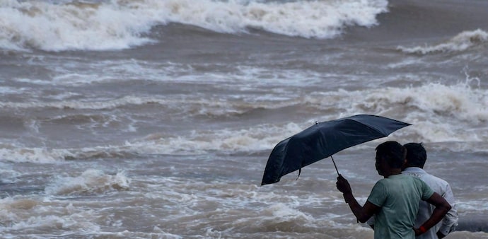
- Nov 18, 2026,
- Updated Nov 18, 2026 1:36 PM IST
Cyclone Akvan is gaining strength over the Bay of Bengal and is expected to become a Very Severe Cyclonic Storm before crossing the Andhra Pradesh coast on November 20, bringing winds of up to 145 kmph, extremely heavy rain and a risk of flooding in several coastal districts.
The India Meteorological Department (IMD) said Akvan was moving slowly northwards and was centred over the central parts of the South and adjoining Westcentral Bay of Bengal at 2:30 am on Wednesday.
The storm was about 590 km east of Chennai, 620 km southeast of Machilipatnam and 620 km south-southeast of Visakhapatnam.
When will Cyclone Akvan make landfall?
Akvan is expected to intensify into a Severe Cyclonic Storm around the morning of November 18 and become a Very Severe Cyclonic Storm around the evening of November 19.
The cyclone will then continue moving northwestwards and is likely to cross the Andhra Pradesh and Yanam coasts between Nellore and Visakhapatnam around noon on November 20.
At landfall, its maximum sustained wind speed is expected to be 120-130 kmph, gusting to 145 kmph.
Don't Miss: Third cyclone in three weeks? IMD warns of severe storm by Nov 17, Odisha on high alert
The IMD's forecast shows the cyclone strengthening through November 19. By the evening of November 19, wind speeds are expected to reach 120-130 kmph, with gusts up to 145 kmph.
Extremely heavy rain expected in Andhra
Rain will become a major concern as Akvan moves closer to the coast.
Coastal Andhra Pradesh is likely to see light to moderate rain at many places on November 18, with heavy rain at isolated places. On November 19 and 20, rainfall is expected to become more intense, with heavy to very heavy rain at a few places and isolated extremely heavy rainfall of 21 cm or more.
Heavy rain is also expected in south coastal Odisha from November 19 to 21.
The IMD has issued rainfall warnings for several other regions, including Rayalaseema, eastern Telangana, Chhattisgarh, Gangetic West Bengal, Jharkhand, East Vidarbha and East Madhya Pradesh.
Storm surge threat along Andhra coast
The cyclone could also push seawater into low-lying coastal areas.
The IMD has warned of a 0.4 to 1.2 metre storm surge above the astronomical tide during landfall in parts of Andhra Pradesh.
Prakasam, Bapatla, Krishna, West Godavari, Konaseema, Kakinada and Visakhapatnam are among the districts that could see inundation.
The peak surge is expected over Bapatla, Krishna, West Godavari and Kakinada from the morning to afternoon of November 20.
Winds and sea conditions to worsen
Winds along and off the Andhra Pradesh and Yanam coasts are expected to reach 60-70 kmph, gusting to 80 kmph, from the evening of November 18.
The winds could then rise to 120-130 kmph, gusting to 145 kmph, from the night of November 19 until landfall on November 20.
Sea conditions will also deteriorate sharply. The IMD expects the sea to become high to very high on November 19 morning and phenomenal from November 19 evening until landfall.
Must Read: Cyclone alert: Bay of Bengal storm keeps Chennai and Andhra coast on edge. Where will it strike?
Roads, power and crops could be hit
The IMD has warned of major damage to thatched, hut and kutcha houses in coastal Andhra Pradesh. Roofs could be blown off, while loose metal sheets, hoardings and tree branches could become dangerous.
Power and communication poles could also be damaged, while large trees may be uprooted.
The storm could cause major damage to standing and coastal crops, plantations and orchards. Banana, papaya and drumstick trees are among the crops specifically mentioned in the warning.
Travel could also be affected, with the IMD warning of waterlogging, flooding of roads and disruption to railways, overhead power lines, signalling systems, airports and heliports.
Fishermen warned to stay away from sea
The IMD has advised fishermen not to venture into the warned areas of the Bay of Bengal.
Fishing operations are to remain suspended in the Southwest Bay of Bengal until November 20 and in the Westcentral Bay of Bengal until November 21. Fishing is also prohibited in the Northwest Bay of Bengal during November 19-21.
People living in coastal hutments have been advised to move to safer places. Those in affected areas have been asked to remain indoors and avoid vulnerable structures.
The IMD has also warned of possible riverine, urban and coastal flooding, as well as possible landslides in hilly areas.
The next bulletin on Cyclone Akvan will be issued at 8:30 am on November 18.
Cyclone Akvan is gaining strength over the Bay of Bengal and is expected to become a Very Severe Cyclonic Storm before crossing the Andhra Pradesh coast on November 20, bringing winds of up to 145 kmph, extremely heavy rain and a risk of flooding in several coastal districts.
The India Meteorological Department (IMD) said Akvan was moving slowly northwards and was centred over the central parts of the South and adjoining Westcentral Bay of Bengal at 2:30 am on Wednesday.
The storm was about 590 km east of Chennai, 620 km southeast of Machilipatnam and 620 km south-southeast of Visakhapatnam.
When will Cyclone Akvan make landfall?
Akvan is expected to intensify into a Severe Cyclonic Storm around the morning of November 18 and become a Very Severe Cyclonic Storm around the evening of November 19.
The cyclone will then continue moving northwestwards and is likely to cross the Andhra Pradesh and Yanam coasts between Nellore and Visakhapatnam around noon on November 20.
At landfall, its maximum sustained wind speed is expected to be 120-130 kmph, gusting to 145 kmph.
Don't Miss: Third cyclone in three weeks? IMD warns of severe storm by Nov 17, Odisha on high alert
The IMD's forecast shows the cyclone strengthening through November 19. By the evening of November 19, wind speeds are expected to reach 120-130 kmph, with gusts up to 145 kmph.
Extremely heavy rain expected in Andhra
Rain will become a major concern as Akvan moves closer to the coast.
Coastal Andhra Pradesh is likely to see light to moderate rain at many places on November 18, with heavy rain at isolated places. On November 19 and 20, rainfall is expected to become more intense, with heavy to very heavy rain at a few places and isolated extremely heavy rainfall of 21 cm or more.
Heavy rain is also expected in south coastal Odisha from November 19 to 21.
The IMD has issued rainfall warnings for several other regions, including Rayalaseema, eastern Telangana, Chhattisgarh, Gangetic West Bengal, Jharkhand, East Vidarbha and East Madhya Pradesh.
Storm surge threat along Andhra coast
The cyclone could also push seawater into low-lying coastal areas.
The IMD has warned of a 0.4 to 1.2 metre storm surge above the astronomical tide during landfall in parts of Andhra Pradesh.
Prakasam, Bapatla, Krishna, West Godavari, Konaseema, Kakinada and Visakhapatnam are among the districts that could see inundation.
The peak surge is expected over Bapatla, Krishna, West Godavari and Kakinada from the morning to afternoon of November 20.
Winds and sea conditions to worsen
Winds along and off the Andhra Pradesh and Yanam coasts are expected to reach 60-70 kmph, gusting to 80 kmph, from the evening of November 18.
The winds could then rise to 120-130 kmph, gusting to 145 kmph, from the night of November 19 until landfall on November 20.
Sea conditions will also deteriorate sharply. The IMD expects the sea to become high to very high on November 19 morning and phenomenal from November 19 evening until landfall.
Must Read: Cyclone alert: Bay of Bengal storm keeps Chennai and Andhra coast on edge. Where will it strike?
Roads, power and crops could be hit
The IMD has warned of major damage to thatched, hut and kutcha houses in coastal Andhra Pradesh. Roofs could be blown off, while loose metal sheets, hoardings and tree branches could become dangerous.
Power and communication poles could also be damaged, while large trees may be uprooted.
The storm could cause major damage to standing and coastal crops, plantations and orchards. Banana, papaya and drumstick trees are among the crops specifically mentioned in the warning.
Travel could also be affected, with the IMD warning of waterlogging, flooding of roads and disruption to railways, overhead power lines, signalling systems, airports and heliports.
Fishermen warned to stay away from sea
The IMD has advised fishermen not to venture into the warned areas of the Bay of Bengal.
Fishing operations are to remain suspended in the Southwest Bay of Bengal until November 20 and in the Westcentral Bay of Bengal until November 21. Fishing is also prohibited in the Northwest Bay of Bengal during November 19-21.
People living in coastal hutments have been advised to move to safer places. Those in affected areas have been asked to remain indoors and avoid vulnerable structures.
The IMD has also warned of possible riverine, urban and coastal flooding, as well as possible landslides in hilly areas.
The next bulletin on Cyclone Akvan will be issued at 8:30 am on November 18.