
From Nepal to Bihar: How 4 Himalayan rivers can turn a flood in Nepal into India’s crisis
A flash flood in Nepal can rapidly become a cross-border threat as Himalayan rivers carry surges into the plains of Bihar and Uttar Pradesh. Here’s how the Gandak, Kosi, Bagmati and Ghaghara create four major pathways through which flooding in Nepal can affect India.
- Aug 27, 2026,
- Updated Aug 27, 2026 4:31 PM IST
A flash flood in Nepal can quickly become a downstream concern for India because several major rivers flowing through Bihar and Uttar Pradesh originate in or draw substantial water from Himalayan catchments across the border. The Gandak, Kosi, Bagmati and Ghaghara form four distinct pathways through which extreme rainfall and sudden flood surges in Nepal can affect the Indian plains, according to news reports.
What happened in Nepal?
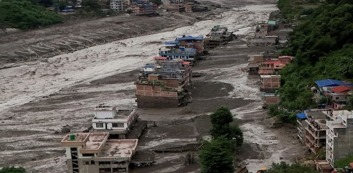
According to the International Centre for Integrated Mountain Development (ICIMOD), a flash flood struck Nepal’s Rasuwa district on the morning of August 26, sending a powerful surge of water, sediment and boulders through the Bhote Koshi and Trishuli river systems.
Water levels in the Bhote Koshi basin began rising sharply at around 9 am local time. The flood wave then moved downstream into the Trishuli river.
ICIMOD described the flood wave as exceptionally fast. At Galchchi, water levels in the Trishuli surged by as much as nine metres within just 30 minutes.
A preliminary assessment suggested that a large volume of ice and rock debris may have entered Lende Khola, a tributary of the Bhote Koshi, triggering the sudden surge. However, ICIMOD said the exact cause of the flash flood had not yet been conclusively established.
MUST READ: Nepal flood: Sadhguru was headed to the same Tibet centre where 80 Isha pilgrims went out of contact
The floodwater then travelled downstream through the Bhote Koshi and Trishuli rivers. Further downstream, the Narayani-Gandak river system provides the natural route for the water towards India.
Immediate threat
The immediate threat from the latest flash flood in Nepal’s Rasuwa district has eased, with discharge at the Valmikinagar Gandak Barrage falling to around 81,000 cusecs. But the episode highlights the wider cross-border flood risk.
Gandak: From Narayani to Bihar
The Gandak, known as the Narayani in Nepal, was at the centre of the latest flood alert. The surge originated near the Nepal-Tibet border in the Bhote Koshi/Lhende river system before moving into the Trishuli river system.
MUST READ: Nepal flash floods: 21 Indian tourists rescued so far, over 160 bodies recovered - Top developments
The Trishuli forms part of the Narayani basin and eventually joins other major tributaries around Devghat. The combined river then flows south towards India, where it is known as the Gandak.
The river enters India near Valmikinagar in West Champaran, Bihar. From there, it flows through several districts, including East Champaran, Gopalganj, Muzaffarpur, Saran and Vaishali, before joining the Ganga near Hajipur.
Kosi and Nepal-to-Bihar flood pathway
The Kosi is a separate river system but represents another major Nepal-to-Bihar flood pathway. Its principal upper tributaries—the Sun Kosi, Arun and Tamur—come together to form the Saptakoshi system.
The river enters Bihar near Bhimnagar and flows through or affects districts including Supaul, Saharsa, Madhepura, Araria, Purnia, Katihar, Madhubani, Darbhanga and Khagaria.
Its flood risk is amplified by the enormous sediment load it carries from the Himalayas. As the river reaches the flatter plains, sediment accumulation and the reduced gradient can contribute to flooding and changes in the river’s course.
Bagmati: Nepal’s hills to north Bihar
The Bagmati originates in Nepal’s Shivapuri range north of Kathmandu before flowing through the Kathmandu Valley and southwards into the Terai.
It enters India in Bihar’s Sitamarhi district near Dheng and then flows through the northern plains. Heavy rainfall in its mountainous upper catchment can therefore send large volumes of water towards relatively flat areas of north Bihar, where drainage can be slow.
Ghaghara: Nepal’s Karnali to Uttar Pradesh
In Nepal, the Ghaghara is known as the Karnali. It originates in the Himalayan region near Tibet and gathers water from several mountain tributaries before entering India.
The river is a major flood pathway for Uttar Pradesh and eventually flows into Bihar before joining the Ganga near Chhapra.
Which parts of India could be affected?
The areas most directly exposed are along the Gandak corridor in eastern Uttar Pradesh and Bihar. In Uttar Pradesh, Kushinagar, Deoria and Maharajganj are among the districts identified as vulnerable to flooding in the Gandak basin, with Kushinagar’s Khadda tehsil particularly exposed because of its proximity to the river.
In Bihar, the Gandak flows through or along West Champaran, East Champaran, Gopalganj, Muzaffarpur, Siwan, Saran and Vaishali before joining the Ganga. However, the greatest risk is concentrated around the river, embankments and floodplains.
Following the Nepal flood, all 36 gates of the Gandak barrage were opened, with about 150,000 cusecs released by 11 pm on August 26. Authorities and NDRF teams were placed on high alert.
The situation could change quickly depending on the volume and speed of water moving downstream. Localised flooding could affect low-lying settlements, agricultural land and roads near the river. Officials are closely monitoring water levels and barrage releases, while district administrations have been advised to remain prepared for evacuation and rescue operations if conditions worsen.
(With PTI and agency inputs)
A flash flood in Nepal can quickly become a downstream concern for India because several major rivers flowing through Bihar and Uttar Pradesh originate in or draw substantial water from Himalayan catchments across the border. The Gandak, Kosi, Bagmati and Ghaghara form four distinct pathways through which extreme rainfall and sudden flood surges in Nepal can affect the Indian plains, according to news reports.
What happened in Nepal?
According to the International Centre for Integrated Mountain Development (ICIMOD), a flash flood struck Nepal’s Rasuwa district on the morning of August 26, sending a powerful surge of water, sediment and boulders through the Bhote Koshi and Trishuli river systems.
Water levels in the Bhote Koshi basin began rising sharply at around 9 am local time. The flood wave then moved downstream into the Trishuli river.
ICIMOD described the flood wave as exceptionally fast. At Galchchi, water levels in the Trishuli surged by as much as nine metres within just 30 minutes.
A preliminary assessment suggested that a large volume of ice and rock debris may have entered Lende Khola, a tributary of the Bhote Koshi, triggering the sudden surge. However, ICIMOD said the exact cause of the flash flood had not yet been conclusively established.
MUST READ: Nepal flood: Sadhguru was headed to the same Tibet centre where 80 Isha pilgrims went out of contact
The floodwater then travelled downstream through the Bhote Koshi and Trishuli rivers. Further downstream, the Narayani-Gandak river system provides the natural route for the water towards India.
Immediate threat
The immediate threat from the latest flash flood in Nepal’s Rasuwa district has eased, with discharge at the Valmikinagar Gandak Barrage falling to around 81,000 cusecs. But the episode highlights the wider cross-border flood risk.
Gandak: From Narayani to Bihar
The Gandak, known as the Narayani in Nepal, was at the centre of the latest flood alert. The surge originated near the Nepal-Tibet border in the Bhote Koshi/Lhende river system before moving into the Trishuli river system.
MUST READ: Nepal flash floods: 21 Indian tourists rescued so far, over 160 bodies recovered - Top developments
The Trishuli forms part of the Narayani basin and eventually joins other major tributaries around Devghat. The combined river then flows south towards India, where it is known as the Gandak.
The river enters India near Valmikinagar in West Champaran, Bihar. From there, it flows through several districts, including East Champaran, Gopalganj, Muzaffarpur, Saran and Vaishali, before joining the Ganga near Hajipur.
Kosi and Nepal-to-Bihar flood pathway
The Kosi is a separate river system but represents another major Nepal-to-Bihar flood pathway. Its principal upper tributaries—the Sun Kosi, Arun and Tamur—come together to form the Saptakoshi system.
The river enters Bihar near Bhimnagar and flows through or affects districts including Supaul, Saharsa, Madhepura, Araria, Purnia, Katihar, Madhubani, Darbhanga and Khagaria.
Its flood risk is amplified by the enormous sediment load it carries from the Himalayas. As the river reaches the flatter plains, sediment accumulation and the reduced gradient can contribute to flooding and changes in the river’s course.
Bagmati: Nepal’s hills to north Bihar
The Bagmati originates in Nepal’s Shivapuri range north of Kathmandu before flowing through the Kathmandu Valley and southwards into the Terai.
It enters India in Bihar’s Sitamarhi district near Dheng and then flows through the northern plains. Heavy rainfall in its mountainous upper catchment can therefore send large volumes of water towards relatively flat areas of north Bihar, where drainage can be slow.
Ghaghara: Nepal’s Karnali to Uttar Pradesh
In Nepal, the Ghaghara is known as the Karnali. It originates in the Himalayan region near Tibet and gathers water from several mountain tributaries before entering India.
The river is a major flood pathway for Uttar Pradesh and eventually flows into Bihar before joining the Ganga near Chhapra.
Which parts of India could be affected?
The areas most directly exposed are along the Gandak corridor in eastern Uttar Pradesh and Bihar. In Uttar Pradesh, Kushinagar, Deoria and Maharajganj are among the districts identified as vulnerable to flooding in the Gandak basin, with Kushinagar’s Khadda tehsil particularly exposed because of its proximity to the river.
In Bihar, the Gandak flows through or along West Champaran, East Champaran, Gopalganj, Muzaffarpur, Siwan, Saran and Vaishali before joining the Ganga. However, the greatest risk is concentrated around the river, embankments and floodplains.
Following the Nepal flood, all 36 gates of the Gandak barrage were opened, with about 150,000 cusecs released by 11 pm on August 26. Authorities and NDRF teams were placed on high alert.
The situation could change quickly depending on the volume and speed of water moving downstream. Localised flooding could affect low-lying settlements, agricultural land and roads near the river. Officials are closely monitoring water levels and barrage releases, while district administrations have been advised to remain prepared for evacuation and rescue operations if conditions worsen.
(With PTI and agency inputs)