
'Biggest El Niño ever recorded': Economist Sanjeev Sanyal highlights record-breaking Pacific heat
The World Meteorological Organisation has also warned that the ongoing event could become the strongest El Niño ever recorded
- Sep 27, 2026,
- Updated Sep 27, 2026 5:00 AM IST
A powerful El Niño event developing across the Pacific Ocean has already broken a sea-surface temperature record, months before the climate phenomenon is expected to reach its peak.
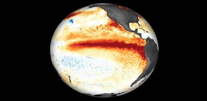
Economist and Economic Advisory Council member Sanjeev Sanyal highlighted the development in a post on X, writing, “We currently going through the biggest El Niño event ever recorded.” His post shared an image showing the unusually warm waters spreading across the Pacific.
According to a recent report by Science News, the current El Niño has reached an intensity that is unprecedented in recorded daily measurements. On September 21, sea-surface temperatures in the central and eastern equatorial Pacific were 3.08 degrees Celsius above the 1991–2020 average. The previous most extreme daily anomaly was 3.02 degrees Celsius, recorded during the 2015–16 El Niño.
READ THIS: India ranks 4th among countries worst hit by heat-related deaths due to Super El Nino. Here's how
El Niño could strengthen further
Scientists quoted by Science News said the event is likely to intensify further, with its peak expected in the coming months. However, there is an important distinction between the current record and declaring it the strongest El Niño ever.
NOAA uses a rolling three-month average rather than a single day's temperature anomaly to assess El Niño strength. Under NOAA's newer Relative Oceanic Niño Index, the current event has not yet surpassed the strength of the major 1997–98 El Niño. Forecasts, however, indicate that the current event could break that record in the months ahead.
The World Meteorological Organisation has also warned that the ongoing event could become the strongest El Niño ever recorded. In an earlier September assessment, the WMO said the phenomenon was likely to persist into February 2027 amid exceptionally warm Pacific Ocean temperatures.
What does a stronger El Niño mean?
El Niño can influence weather patterns across large parts of the world. Scientists have already linked the current event to conditions including drought in parts of Central America, a weaker Indian monsoon and changes in hurricane activity. Northern South America and the Amazon can also experience drier conditions during El Niño events.
During the later autumn and winter months, El Niño can also bring wetter conditions to the southern United States while producing drier and warmer conditions in parts of the northern US and Canada.
Scientists caution that an exceptionally strong El Niño does not automatically make every associated weather impact more predictable. Rising ocean temperatures caused by broader global warming can alter some of the historical relationships between El Niño and weather patterns.
A powerful El Niño event developing across the Pacific Ocean has already broken a sea-surface temperature record, months before the climate phenomenon is expected to reach its peak.
Economist and Economic Advisory Council member Sanjeev Sanyal highlighted the development in a post on X, writing, “We currently going through the biggest El Niño event ever recorded.” His post shared an image showing the unusually warm waters spreading across the Pacific.
According to a recent report by Science News, the current El Niño has reached an intensity that is unprecedented in recorded daily measurements. On September 21, sea-surface temperatures in the central and eastern equatorial Pacific were 3.08 degrees Celsius above the 1991–2020 average. The previous most extreme daily anomaly was 3.02 degrees Celsius, recorded during the 2015–16 El Niño.
READ THIS: India ranks 4th among countries worst hit by heat-related deaths due to Super El Nino. Here's how
El Niño could strengthen further
Scientists quoted by Science News said the event is likely to intensify further, with its peak expected in the coming months. However, there is an important distinction between the current record and declaring it the strongest El Niño ever.
NOAA uses a rolling three-month average rather than a single day's temperature anomaly to assess El Niño strength. Under NOAA's newer Relative Oceanic Niño Index, the current event has not yet surpassed the strength of the major 1997–98 El Niño. Forecasts, however, indicate that the current event could break that record in the months ahead.
The World Meteorological Organisation has also warned that the ongoing event could become the strongest El Niño ever recorded. In an earlier September assessment, the WMO said the phenomenon was likely to persist into February 2027 amid exceptionally warm Pacific Ocean temperatures.
What does a stronger El Niño mean?
El Niño can influence weather patterns across large parts of the world. Scientists have already linked the current event to conditions including drought in parts of Central America, a weaker Indian monsoon and changes in hurricane activity. Northern South America and the Amazon can also experience drier conditions during El Niño events.
During the later autumn and winter months, El Niño can also bring wetter conditions to the southern United States while producing drier and warmer conditions in parts of the northern US and Canada.
Scientists caution that an exceptionally strong El Niño does not automatically make every associated weather impact more predictable. Rising ocean temperatures caused by broader global warming can alter some of the historical relationships between El Niño and weather patterns.