
China warns new barrier lake near Nepal border could breach, trigger another flood in 3 days
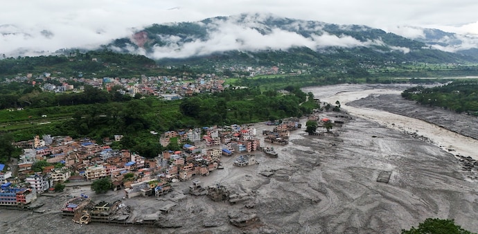
The barrier lake has formed near the confluence of the Chhochen Khola and Purepu Tsangpo rivers in Nepal. Its water volume was estimated at 2 million cubic metres as of Thursday morning
- Aug 27, 2026,
- Updated Aug 27, 2026 7:10 PM IST
A day after a deadly flash flood devastated Nepal, China's Ministry of Water Resources on Thursday warned that another barrier lake has formed near the Nepal-China border and could breach in the next three days.
According to the ministry, the barrier lake has formed near the confluence of the Chhochen Khola and Purepu Tsangpo rivers in Nepal. Its water volume was estimated at 2 million cubic metres as of Thursday morning, and the lake was already overflowing, China Central Television reported.
Another 3 million cubic metres of water could flow into the lake over the next three days, creating a high risk of a breach, the report said.
Don't Miss: From Nepal to Bihar: How 4 Himalayan rivers can turn a flood in Nepal into India’s crisis
Nepal's National Disaster Risk Reduction and Management Authority (NDRRMA) also warned of another major flood risk.
The authority said that the Lhende River has been obstructed about 18 kilometres above the Rasuwagadhi border. Due to the obstruction, the authority added, a lake covering about 0.11 square kilometers has formed.
"As there remains a risk of another major flood, all concerned parties in the lower coastal areas are urged to exercise necessary caution and remain highly vigilant," the NDRRMA said.
In Case You Missed It: Nepal floods: 21 Tamil Nadu pilgrims rescued, 200 more Indians seek evacuation from China side
The warning comes after a similar chain of events triggered Wednesday's deadly flooding in Nepal's Rasuwa district.
NDRRMA said an initial analysis of satellite images by Planet Labs indicated that a snow-rock landslide near the Nepal-China border had caused a glacier-inclusive flood in the Lhende River. The landslide occurred about 20 kilometres northeast of the Rasuwagadhi border crossing.
Must Read: Nepal flood: Sadhguru was headed to the same Tibet centre where 80 Isha pilgrims went out of contact
What Triggered The First Flood
According to Kathmandu Post, scientists analysing satellite imagery said that a massive fall of ice and rock appeared to have blocked a river, creating a temporary dam that later burst and unleashed the flood.
Hours after the tragedy struck, the NDRRMA said on Wednesday that an initial study based on analysis of satellite images indicated that a glacier-inclusive flood occurred in the Lhende River.
This happened, according to the authority, due to a snow-rock landslide that took place on the Nepal-China border, approximately 20 kilometers northeast of the Nepal-China Rasuwagadhi border crossing.
The BBC reported on Thursday that an analysis by the International Centre for Integrated Mountain Development (ICIMOD) found that an "ice-rock avalanche originating from a high-altitude area" may have sent a large volume of ice and rock debris into the Lende Khola.
The river is a tributary of the Bhote Koshi. The debris triggered a sudden surge carrying water, sediment, and large boulders downstream.
Water levels in rivers downstream rose by seven to nine metres within 30 minutes, according to the ICIMOD analysis. Several monitoring stations were washed away or damaged.
A day after a deadly flash flood devastated Nepal, China's Ministry of Water Resources on Thursday warned that another barrier lake has formed near the Nepal-China border and could breach in the next three days.
According to the ministry, the barrier lake has formed near the confluence of the Chhochen Khola and Purepu Tsangpo rivers in Nepal. Its water volume was estimated at 2 million cubic metres as of Thursday morning, and the lake was already overflowing, China Central Television reported.
Another 3 million cubic metres of water could flow into the lake over the next three days, creating a high risk of a breach, the report said.
Don't Miss: From Nepal to Bihar: How 4 Himalayan rivers can turn a flood in Nepal into India’s crisis
Nepal's National Disaster Risk Reduction and Management Authority (NDRRMA) also warned of another major flood risk.
The authority said that the Lhende River has been obstructed about 18 kilometres above the Rasuwagadhi border. Due to the obstruction, the authority added, a lake covering about 0.11 square kilometers has formed.
"As there remains a risk of another major flood, all concerned parties in the lower coastal areas are urged to exercise necessary caution and remain highly vigilant," the NDRRMA said.
In Case You Missed It: Nepal floods: 21 Tamil Nadu pilgrims rescued, 200 more Indians seek evacuation from China side
The warning comes after a similar chain of events triggered Wednesday's deadly flooding in Nepal's Rasuwa district.
NDRRMA said an initial analysis of satellite images by Planet Labs indicated that a snow-rock landslide near the Nepal-China border had caused a glacier-inclusive flood in the Lhende River. The landslide occurred about 20 kilometres northeast of the Rasuwagadhi border crossing.
Must Read: Nepal flood: Sadhguru was headed to the same Tibet centre where 80 Isha pilgrims went out of contact
What Triggered The First Flood
According to Kathmandu Post, scientists analysing satellite imagery said that a massive fall of ice and rock appeared to have blocked a river, creating a temporary dam that later burst and unleashed the flood.
Hours after the tragedy struck, the NDRRMA said on Wednesday that an initial study based on analysis of satellite images indicated that a glacier-inclusive flood occurred in the Lhende River.
This happened, according to the authority, due to a snow-rock landslide that took place on the Nepal-China border, approximately 20 kilometers northeast of the Nepal-China Rasuwagadhi border crossing.
The BBC reported on Thursday that an analysis by the International Centre for Integrated Mountain Development (ICIMOD) found that an "ice-rock avalanche originating from a high-altitude area" may have sent a large volume of ice and rock debris into the Lende Khola.
The river is a tributary of the Bhote Koshi. The debris triggered a sudden surge carrying water, sediment, and large boulders downstream.
Water levels in rivers downstream rose by seven to nine metres within 30 minutes, according to the ICIMOD analysis. Several monitoring stations were washed away or damaged.