
'Land records digitised but...': Amazon exec reveals how Claude AI helped him trace ancestral land in UP village
Khan said he even upgraded from the free plan to Pro and then Max while doing this, as the work required heavy usage.
- May 28, 2026,
- Updated May 28, 2026 3:40 PM IST
Zahid Khan, Director and GM (New Shopping Experiences) at Amazon Bengaluru, has shared how he used artificial intelligence to locate and map his ancestral land in a village in Uttar Pradesh.
In a detailed post on LinkedIn, Khan described how he traced his family’s land in Mohammadpur village. The property had been passed down through generations — from his grandfather to his father, and then to him. He said he had visited the village only a few times in his life and was not sure about the exact location of the land parcels.
He wrote, “My late father inherited land in a small village called Mohammadpur in Uttar Pradesh — passed down from his grandfather, to his father, to him, and now to me. I've only visited that village a handful of times in my life, so I wouldn't know where to look even if I tried.”
Don't Miss: The Rise of Rizwan Sajan: How a Mumbai Boy built Danube, a multi-billion real estate empire in Dubai
Khan also spoke about the challenge of accessing land records. “The land records are digitized — but spread across multiple government websites, all in dense official Hindi that's genuinely hard to parse even if you can read the language. The kind of Hindi that makes legal documents feel like ancient scripture," he wrote.
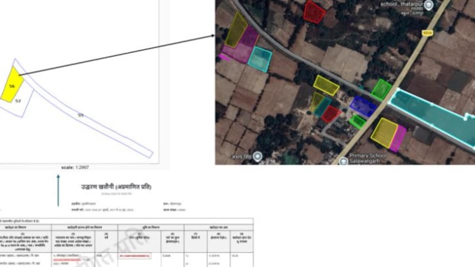
To solve this, he used Claude Cowork with “computer use” features to go through government records and map the land. He searched his father’s name in Hindi to find relevant entries and used Gata Sankhya (plot numbers) to track the exact parcels on official mapping portals.
The AI system then worked through the map data, identified that the coordinates were in UTM format instead of standard latitude and longitude, converted them, and created a KML file with 25 land plots. This file was then uploaded to Google My Maps, helping him see all the plots clearly on a map.
Khan said he even upgraded from the free plan to Pro and then Max while doing this, as the work required heavy usage.
He shared his experience to show how AI tools can make it easier for people to understand and use complex government records, especially in rural and administrative systems.
The post quickly went viral and drew strong reactions online.
One user said, “This is so cool! India definitely has massive amounts of digitised yet still unusable data. AI agents navigating these kinds of government workflows may unlock enormous value over the next few years.” The same user also asked for more technical details of the process or a GitHub repository.
Another user noted, “KML files. Now that's something I haven't heard in almost 15 year . I am gonna do the same to check if what I know about my land and what it throws up. Thanks!”
A third user added, “I need to do this for my ancestral land too! Will use these exact steps. Thanks for sharing!”
Zahid Khan, Director and GM (New Shopping Experiences) at Amazon Bengaluru, has shared how he used artificial intelligence to locate and map his ancestral land in a village in Uttar Pradesh.
In a detailed post on LinkedIn, Khan described how he traced his family’s land in Mohammadpur village. The property had been passed down through generations — from his grandfather to his father, and then to him. He said he had visited the village only a few times in his life and was not sure about the exact location of the land parcels.
He wrote, “My late father inherited land in a small village called Mohammadpur in Uttar Pradesh — passed down from his grandfather, to his father, to him, and now to me. I've only visited that village a handful of times in my life, so I wouldn't know where to look even if I tried.”
Don't Miss: The Rise of Rizwan Sajan: How a Mumbai Boy built Danube, a multi-billion real estate empire in Dubai
Khan also spoke about the challenge of accessing land records. “The land records are digitized — but spread across multiple government websites, all in dense official Hindi that's genuinely hard to parse even if you can read the language. The kind of Hindi that makes legal documents feel like ancient scripture," he wrote.
To solve this, he used Claude Cowork with “computer use” features to go through government records and map the land. He searched his father’s name in Hindi to find relevant entries and used Gata Sankhya (plot numbers) to track the exact parcels on official mapping portals.
The AI system then worked through the map data, identified that the coordinates were in UTM format instead of standard latitude and longitude, converted them, and created a KML file with 25 land plots. This file was then uploaded to Google My Maps, helping him see all the plots clearly on a map.
Khan said he even upgraded from the free plan to Pro and then Max while doing this, as the work required heavy usage.
He shared his experience to show how AI tools can make it easier for people to understand and use complex government records, especially in rural and administrative systems.
The post quickly went viral and drew strong reactions online.
One user said, “This is so cool! India definitely has massive amounts of digitised yet still unusable data. AI agents navigating these kinds of government workflows may unlock enormous value over the next few years.” The same user also asked for more technical details of the process or a GitHub repository.
Another user noted, “KML files. Now that's something I haven't heard in almost 15 year . I am gonna do the same to check if what I know about my land and what it throws up. Thanks!”
A third user added, “I need to do this for my ancestral land too! Will use these exact steps. Thanks for sharing!”