


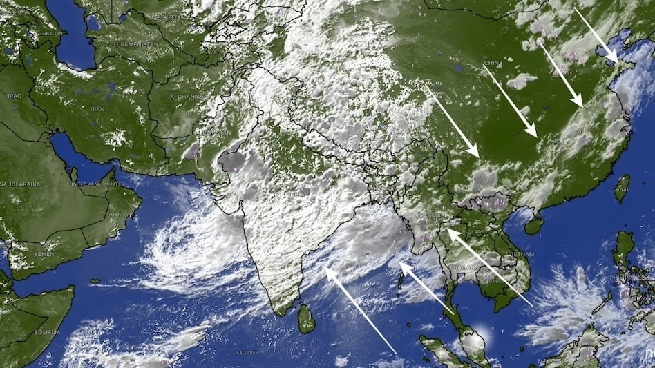
 The sprawling rain band extends across north India, the Himalayan region, China and onward to South Korea
A vast monsoon cloud band stretching between 7,000 and 10,000 kilometres from northern India to South Korea has emerged in satellite imagery, India Today reported on Thursday. This marks one of the most active phases of the 2026 Southwest monsoon, and is delivering widespread rainfall across large parts of Asia.
The sprawling rain band extends across north India, the Himalayan region, China and onward to South Korea.

 NSE IPO: Exchange raises Rs 6,746 crore from 189 anchor investors; LIC, GIC, Fidelity among buyers
 India’s chip push goes global: Semiconductor heavyweights deepen footprint ahead of SEMICON 2026
 NSE IPO opens tomorrow: Brokerage weighs growth prospects, valuation; what GMP indicates
 UPI MDR: No rollback of 0.4% fee above Rs 2,000; govt says move will make UPI self-sustainable
 From Rs 300 to Rs 25,000: How the wage ceiling under EPFO has increased over the years
 “Onion Prices Down 9% In 9 Days”: Nidhi Khare On Availability And ₹35/Kg Retail Sales
 Indian Markets At A Crucial Juncture: Nifty, Crude, Fed & Smallcaps | Jaipuria
 Nifty At 23,200: Crude Oil, U.S. Fed Rate Hike Fears & Market Outlook Explained
 “7.8% Growth Is Not Random”: FM Sitharaman Credits India’s People, Industry And MSMEs
 Indian I.T. Stocks: Why AI Disruption & Weak Growth Are Making Investors Rethink Their Bets
 US Fed rate hike: Why India could face pressure from higher US yields and a stronger dollarNSE IPO: Exchange raises Rs 6,746 crore from 189 anchor investors; LIC, GIC, Fidelity among buyersNSE IPO opens tomorrow: Brokerage weighs growth prospects, valuation; what GMP indicates
 Paytm, KRN Heat Exchanger, Ather Energy, Vishal Mega Mart: Expert shares key entry levels, targets
 FOMC outcome: How stock market may react if Fed rate is hiked by 25 bps today US Fed rate hike: Why India could face pressure from higher US yields and a stronger dollar
 Congress opposes UPI charges now. But 5 of its MPs backed Finance panel's MDR push
 PIL filed in Supreme Court against new UPI MDR
 'There is no boundary between Pakistan and China': India rejects joint commission over Indian territory
 ‘Do it without borrowing money’: Nithin Kamath recalls how a ₹25,000 credit card debt changed his money habits












