

 Although Category 5 storms are relatively rare, they account for some of history's most catastrophic weather disasters because of their extreme winds, torrential rainfall and coastal flooding. Although Category 5 storms are relatively rare, they account for some of history's most catastrophic weather disasters because of their extreme winds, torrential rainfall and coastal flooding.
 As Super Typhoon Bavi races towards the Mariana Islands with Category 5-equivalent strength, it has once again drawn attention to the world's most powerful tropical cyclones. With sustained winds exceeding 252 km/h, these storms are capable of unleashing catastrophic winds, storm surge and torrential rain in a matter of hours.
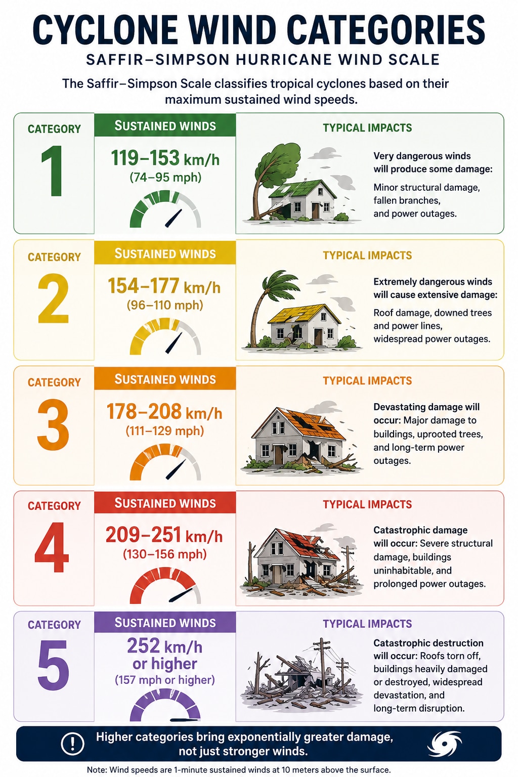
When a tropical cyclone reaches Category 5, it has entered the highest classification on the Saffir–Simpson Hurricane Wind Scale. These are the most powerful storms on Earth, capable of flattening homes, uprooting forests, triggering devastating storm surges and leaving widespread destruction in their wake.
Although Category 5 storms are relatively rare, they account for some of history's most catastrophic weather disasters because of their extreme winds, torrential rainfall and coastal flooding.
MUST READ | Super Typhoon Bavi threatens US Pacific islands: What makes it a Category-5 beast?
But what exactly qualifies a storm as Category 5, and what conditions allow a tropical cyclone like Bavi to reach such extraordinary intensity? Here's a closer look at the science behind these rare and devastating weather systems.
What is a Category 5 cyclone?
A Category 5 cyclone is a tropical cyclone with maximum sustained winds of at least 252 km/h (157 mph). It represents the highest level on the Saffir–Simpson Hurricane Wind Scale, which classifies storms solely by their sustained wind speeds.
While different ocean basins use different names — hurricanes in the Atlantic and eastern Pacific, typhoons in the western Pacific, and cyclones in the Indian Ocean and South Pacific — they are all the same type of weather system.
How does a Category 5 cyclone form?
Not every tropical storm becomes a Category 5 cyclone. It requires an almost perfect combination of atmospheric and oceanic conditions.
1. Warm ocean waters: Cyclones draw their energy from warm seas. Water temperatures generally need to be at least 26.5°C, but many Category 5 storms develop over waters closer to 29-31°C, providing enormous amounts of heat and moisture.
2. A pre-existing weather disturbance: The process often begins with a cluster of thunderstorms or a tropical disturbance over warm ocean waters. As warm, moist air rises, it creates an area of low pressure that pulls in more air from the surrounding region.
3. Earth's rotation: The Coriolis effect, caused by Earth's rotation, makes the incoming air spiral around the low-pressure centre. This creates the familiar rotating structure of a tropical cyclone. Because the Coriolis effect is weak near the Equator, cyclones rarely form within about five degrees of it.
4. Low wind shear: For a cyclone to strengthen, winds at different heights in the atmosphere must remain relatively similar. Strong vertical wind shear can tilt or tear apart the storm, preventing it from organising.
5. High humidity: Moist air in the middle levels of the atmosphere fuels thunderstorm development, allowing the cyclone to build a strong and organised circulation.
6. Rapid intensification: Some storms undergo rapid intensification, meaning their sustained winds increase dramatically within 24 hours. This usually occurs when exceptionally warm water, deep ocean heat and favourable atmospheric conditions combine, allowing the cyclone to strengthen at an extraordinary pace.
Why are Category 5 cyclones so destructive?
Many people assume the wind is the biggest danger, but Category 5 cyclones bring multiple life-threatening hazards simultaneously.
What is the eye of the storm?
The eye is the calm centre of the cyclone, often spanning 20-50 km in diameter. It is surrounded by the eyewall, where the strongest winds and heaviest rain occur.
People sometimes mistakenly believe the storm has passed when the eye moves overhead. In reality, the most dangerous conditions often return quickly as the opposite side of the eyewall arrives, bringing violent winds from the opposite direction.
Some of the strongest Category 5 cyclones
Scientists say climate change is not necessarily increasing the total number of tropical cyclones, but warming oceans are increasing the likelihood that storms will intensify more rapidly and reach the highest categories.
Warmer seas provide more energy, while a warmer atmosphere can hold more moisture, increasing the potential for heavier rainfall. As sea levels rise, storm surges can also reach farther inland, worsening coastal flooding.
 Political stability beats high returns: The world's safest countries for investors in 2026
 Centre cracks down on Meta over child sexual abuse ads on Instagram; seeks reply in 7 days
 Mumbai rains: Red alert remains as 300 mm+ rain batters city; BMC urges residents to stay safe
 and gusts reaching 315 km/h (196 mph), the storm has strengthened into a Category 5-equivalent system over exceptionally warm ocean waters.") Super Typhoon Bavi threatens US Pacific islands: What makes it a Category-5 beast?
Super Typhoon Bavi threatens US Pacific islands: What makes it a Category-5 beast? Zomato, Swiggy shares: How to play the quick commerce theme ahead of a potential Zepto IPO
 Mega IPOs To Shake Indian Stock Market? SBI AMC, NSE, Jio Platforms And Liquidity Impact Explained
 Power Demand Is Booming: Market Expert Reveals Why Energy Stocks Could Be The Next Winners
 Lower PF Contribution Ceiling Explained: Will Higher Take-Home Salary Increase Your Tax?
 FMCG Stocks Vs Consumption Plays: Where Should Investors Put Their Money Now? Devang Explained
 Delhi EV Policy Under Scanner: India Today Finds Defunct Charging Stations Across CityZomato, Swiggy shares: How to play the quick commerce theme ahead of a potential Zepto IPO
 YES Bank, HDFC Bank, Axis Bank, RBL Bank, IDFC First: Banking stocks to buy ahead of Q1 show
 Sterlite Tech, Olectra Greentech, Kaynes Tech shares: Buy, hold or sell? Trading strategy
 HCLTech, Mphasis, Persistent, Tech Mahindra, Zensar Tech: Brokerage revises ratings, share price targets
 Midcap, smallcap stocks offer fresh value as earnings support revival, says Devang Mehta