

 Sea surface temperatures in parts of the tropical Pacific have risen sharply in recent months, in some places climbing more than 1°C above normal near the western coast of South America. Sea surface temperatures in parts of the tropical Pacific have risen sharply in recent months, in some places climbing more than 1°C above normal near the western coast of South America.
 A powerful El Niño is developing rapidly in the Pacific Ocean, and climate scientists say it could become one of the strongest events seen in decades by late 2026 or early 2027.
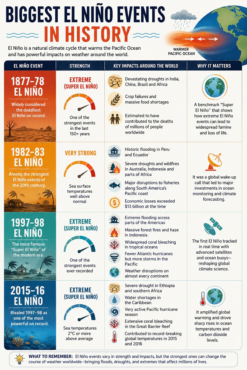
According to the latest forecast from the US National Oceanic and Atmospheric Administration (NOAA), there is now a strong probability that the warming event could become “strong” or even “very strong” — often referred to informally as a “Super El Niño”.
MUST READ | BT Explainer: India’s heat map turns alarming: What 45°C+ temperatures mean for the economy, people
The concern is significant because El Niño has the power to reshape weather patterns across the globe, triggering floods, droughts, heat waves, wildfires, delayed monsoon and disruptions to food and water supplies.
What is El Niño?
El Niño is a naturally occurring climate cycle caused by unusually warm ocean temperatures in the central and eastern tropical Pacific Ocean.
Normally, trade winds push warm surface water westward across the Pacific. During an El Niño event, those winds weaken, allowing warm water to spread eastward toward the Americas.
That warming changes atmospheric circulation worldwide, influencing rainfall, storms, temperatures and monsoon systems across continents. El Niño events usually occur every two to seven years and tend to peak between October and February.
Why scientists are concerned this year
Sea surface temperatures in parts of the tropical Pacific have risen sharply in recent months, in some places climbing more than 1°C above normal near the western coast of South America.
Forecast models suggest the warming could intensify significantly through the year.
NOAA estimates:
Some researchers classify a “Super El Niño” when ocean temperatures rise at least 2°C above average. The last event to reach that threshold occurred in 2015-16.
DON'T MISS | Low monsoons may not be much of a worry for the Indian economy. Here’s why
How El Niño affects global weather
El Niño changes atmospheric circulation patterns, meaning some parts of the world become much wetter while others turn hotter and drier.
Hurricane season flip: Strong El Niño events often suppress Atlantic hurricanes because stronger upper-level winds tear apart developing storms.
That usually means:
Impact on India and Asia: El Niño is closely monitored in India because it can weaken the southwest monsoon.
Historically, strong El Niño years are associated with:
This can affect agriculture, food prices, hydropower generation and rural incomes. Warm and dry winters are also more common in parts of southern and eastern Asia during strong El Niño years.
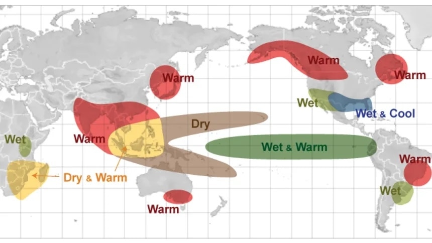
Impact on Africa and the Americas: Scientists warn that drought conditions could intensify in parts of southern Africa during the Southern Hemisphere summer.
Meanwhile, some regions of the Americas may experience:
DO CHECKOUT | Heatwave to sweep across India in 48 hours: 2026 summers set to beat the heat record of 2024
A stronger El Niño can also temporarily push global temperatures higher, especially when combined with long-term human-driven climate change. Researchers caution that El Niño forecasts can still change because ocean temperatures and atmospheric conditions interact in complex ways.
But with Pacific Ocean temperatures rising rapidly, climate agencies worldwide are watching closely. If the developing El Niño strengthens further, it could become one of the defining global weather events of the next two years.
 Govt eases footwear import norms for R&D, extends compliance relief by 1 year
") 'Ships are starting to move...': Trump announces Strait of Hormuz open after US-Iran peace deal
'Ships are starting to move...': Trump announces Strait of Hormuz open after US-Iran peace deal  Sarvam AI becomes unicorn with $234 million funding; HCLTech leads with $150 million
 USTR to visit India on June 22 to take trade talks forward
 and April ($.4.2 billion).") India’s exports to West Asia recover in May as new routes, ports open up
India’s exports to West Asia recover in May as new routes, ports open up After E20, What's Next? AIDA Maps India's Ethanol Road Ahead
 Should Retail Investors Stop SIPs After 2 Years Of Weak Nifty Returns? Expert Explains
 Oil Drops Below $80: Is The Worst Over For The Rupee And Indian Markets?
 Market Masters LIVE: Can WhiteOak Midcap Fund Be Your Next Wealth Creator? | Aashish Somaiyaa Speaks
 FCNR Deposits Explained: Can RBI’s Big Move Bring $50 Billion To India?
 Vedanta's four demerged entities end lower on debut, shares slip up to 5%
 YES Bank shares climb 7% in two sessions; here's what analysts are saying
 Sensex, Nifty extend gains; what's next for the market?
 JSW Energy shares set for a 16% upside post MCCPL acquisition; here's why
  This ferrochrome major gave over 400% stock return in the last five years