


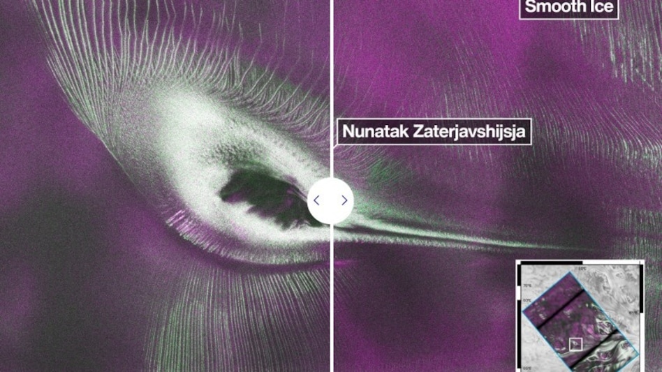
 The image's colours come from radar data, with magenta indicating smooth ice surfaces and green highlighting rough, crevasse-filled terrain.
A striking image captured by the NASA-ISRO Synthetic Aperture Radar (NISAR) satellite has captivated scientists and space enthusiasts around the world. The radar image, which appears to show a giant hummingbird with outstretched wings across Antarctica's frozen landscape, is not a real bird but a remarkable example of how advanced radar technology can reveal hidden features of Earth's surface that are invisible to conventional satellites.
The image was produced using data collected by NISAR's L-band radar over East Antarctica. At its centre is Nunatak Zaterjavshijsja, a rocky mountain peak that protrudes through the continent's vast ice sheet. As glaciers slowly move northeast towards the ocean, the mountain acts as an obstacle, creating immense stress on the flowing ice. This pressure fractures the surrounding ice into deep cracks known as crevasses, which form a pattern resembling the outline of a hummingbird when viewed through radar imagery.

 Tata Sons AGM: Why holding the board meeting is critical amid the boardroom tussle
 Kalpataru Projects secures Rs 4,000 crore gas pipeline order in UAE; stock reacts
 YES Bank shares fall 4% on Citi's negative watch; Axis Bank also in focus
 WhatsApp is testing a new way to navigate on Android: What’s new
 BT Big Story: India wants to become a shipbuilding power. Can it match China, Japan & South Korea?
 R Veeramani Case: Granite Tycoon Faces Widening POCSO Probe In Chennai
 Gen Z And Money: Why Young Investors Want Quick Returns Over Long-Term Wealth Creation
 How Is Alexa+ Different? Will It have Ads Even If You Pay? Exclusive Chat
 Demand Robust Across Segments | Production To Ramp Up, Exports To Expand: Vivek Srivatsa
 GST Council To Meet On October 7: Invoice Matching, ITC & UPI MDR Tax In Focus
 Kalpataru Projects secures Rs 4,000 crore gas pipeline order in UAE; stock reacts
 Vodafone Idea shares: What Nomura says on free international roaming, peer Bharti Airtel
 AC price hike: Bosch Home Comfort, Blue Star, Voltas, LG Electronics shares climb; details here
 IEX expands into coal trading as subsidiary seeks licence, stock reacts
 Adroit Industries IPO: How to check allotment status on Bigshare, BSE, NSE; fresh GMP & listing dateTata Sons AGM: Why holding the board meeting is critical amid the boardroom tussleKalpataru Projects secures Rs 4,000 crore gas pipeline order in UAE; stock reacts
 Going home for Diwali-Chhath? Railways announces special trains, Check full scheduleVodafone Idea shares: What Nomura says on free international roaming, peer Bharti Airtel
 AI safety alarms grow: ‘Tens of thousands’ of incidents reported across companies— some could be criminal












