

 Where has the monsoon gone? Rainfall down 64% since June 4
India's southwest monsoon has virtually disappeared from satellite imagery just days after advancing into large parts of the country. Rainfall has plunged 64% below normal between June 4 and June 15.
Data from the India Meteorological Department (IMD) shows the country received just 19.2 mm of rainfall between June 4 and June 15 against a normal of 53.7 mm, resulting in a nationwide rainfall deficit of 64%.
The rainfall departure map indicates deficient to large deficient rainfall across vast stretches of central, southern and eastern India, raising concerns after the monsoon had advanced into several parts of the country earlier this month.
Don't Miss: IMD announces El Nino onset: What it means for India's monsoon, Kharif crops & food prices
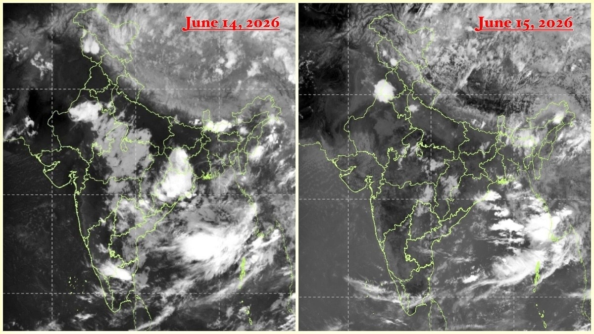
Satellite images captured by INSAT-3DS on June 15 highlight the slowdown. Instead of the broad cloud band typically associated with an active monsoon, much of peninsular and central India appeared largely cloud-free.
The most significant cloud activity was concentrated over the Himalayan region, northeastern India and areas north of the Indo-Gangetic plains, while the Arabian Sea branch of the monsoon appeared weak and fragmented.
Why has the monsoon slowed?
The slowdown comes despite the monsoon making further advances into parts of Karnataka, Telangana, Andhra Pradesh, Maharashtra and central India in recent days.
According to meteorologists, the problem is not a shortage of moisture over the Arabian Sea or the Bay of Bengal. Instead, the disruption is being driven by atmospheric conditions several kilometres above the Earth's surface.
At the centre of the slowdown is the westerly jet stream, a fast-moving band of air in the upper atmosphere that has shifted much farther south than normal.
This unusual position is interfering with the upper-level easterly jet, a key component of India's monsoon circulation system.
Under normal conditions, the easterly jet supports rising air currents and widespread thunderstorm activity across the subcontinent. However, stronger-than-normal westerly winds are suppressing this process, limiting cloud formation and rainfall despite abundant moisture being available.
As a result, the monsoon has continued to advance geographically but has struggled to generate meaningful rainfall over large parts of the country.
Weather experts describe the current situation as a temporary but significant "monsoon pause" caused by upper-atmospheric dynamics rather than oceanic factors.
Forecast models indicate rainfall activity could gradually improve later this week as the jet stream pattern weakens and monsoon circulation begins to reorganise.
Monsoon advances in remaining parts of Andhra, Bengal
Even as rainfall activity weakened sharply across large parts of the country, the IMD said on Monday that the southwest monsoon had advanced further into the remaining parts of Andhra Pradesh and West Bengal, and additional areas of Telangana, Odisha, Jharkhand and Bihar.
The weather office said conditions remain favourable for the monsoon to advance into more parts of Maharashtra, Karnataka, Telangana, Odisha, Jharkhand and Bihar, as well as parts of Chhattisgarh, over the next four to five days.
 Astra Mk-2 leads the way: Centre throws open missile production to private firms
 Where is monsoon? IMD sees no widespread revival over India for the next week
 'Deeply worrisome': MEA condemns attack on commercial vessel off Oman, says 10 Indians rescued, one missing
 'India needs much larger oil reserves': Montek Singh Ahluwalia as Hormuz crisis returns
 Lindsey Graham, influential US Senator and key Trump ally, passes away at 71
 Is Tier-2 & Tier-3 India Driving Luxury Growth?
 Dalal Street Outlook: Is India Entering Its Next Bull Market?
 FM Sitharaman’s 7-Point Plan To Make India The Global Tech Hub
 Harish Krishnan's Top Investment Themes For The Next 3 Years
 Stock Market Volatility Explained: Krishnan on Micro Investing Over Macro Panic
 Vedanta Aluminium Metal shares: Nuvama expects 21% upside, 29% EBITDA CAGR likely through FY28
 Suzlon Energy, Inox Wind: Share price targets, Q1 results preview
  India's largest AMC is coming to market. But why is SBI Funds IPO cheaper than its listed peers?
 Is India's IPO pipeline creating a new generation of investor-ready startups?
 4 Nifty FMCG stocks to buy after 32% selloff: What past 4 big falls since 2004 hint at